

Southbound Pt. III, day 15, Forecast Goodies
New Smyrna is nice. We’d like to see the keys, though, so we’re waiting on weather.
Here’s the far distant forecast.
FRIDAY...South winds 5 to 10 knots becoming southeast in the afternoon. Seas 3 to 4 feet with occasional seas to 5 feet.
FRIDAY NIGHT...South winds 5 to 10 knots becoming west after midnight. Seas 2 to 3 feet.
SATURDAY...North winds 5 to 10 knots. Seas 2 to 3 feet.
This is starting to look interesting. The Friday afternoon part is a bit sporty, but Friday night and Saturday are our kind of offshore sailing. Wind on the nose switches to on the beam and then continues to back until it’s astern.
The Marine Weather Center email said this:
CFL: ESE-S up to 15k/2-4' Fri25-Sat26
SFL: Variable mostly SW<N under 10k/1-3' Fri25 night; Variable mostly N-NE under 15k/1-4' Sat26
The Central Florida (CFL) is mild. And South Florida is glassy calm.
Here’s the potential schedule for the next few days.
Tue22. Do nothing.
Wed23. Shopping for fresh veggies at Publix. Confirm the forecasts. Book the slip.
Thu24. Take a slip at New Smyrna Marina. Water. Fuel. Laundry. Showers.
Fri25. Depart 10-ish and head out to sea.
Sat26. Arrive St. Lucie Inlet. Scoot up to Jensen Beach Mooring Field. We may need to anchor nearby in case we can’t get a mooring right away. We may go to Stuart and anchor there, too.
If we can get a ball, we plan to stay for a week or two to do mail and other sorts of things.
This afternoon, I’ll draft the float plan.


Southbound Pt. III, day 10, Rescue
Been there. Know a lot of people who’ve been there.
Engine doesn’t work.
Not us. Two fisherman who drifted through the anchorage.

We heard the faint beep-beep from a 75HP, electric start outboard that wasn’t starting. They were prepared. Had an anchor. Seemed to know what they were doing.
But, they couldn’t get the thing to start. And. It seems like the killed the battery trying to get it to start.
So I towed them to the nearest boat launch. It was the very least I could do to help someone stranded like that.

Southbound Pt. III, day 10, Waiting
Waiting for weather in New Smyrna Beach. Weather is pleasant. Anchor is holding.

This is the SafeAnchor app on the iPhone. It shows about 60’ of movement between where I marked the anchor and where we are. In the SW corner of the circle, there’s a bunch of skating around.
Because of the river currents and winds, I don’t really have a rock-solid, “anchor is here” position.
What I need to do is wait for slack tide, and go forward to reset the marker.
What I actually do is push the anchor reset whenever we take the dinghy out and return. So it’s at some random location based on where we happened to be swinging at the time.
We have about 50′ of chain going in two directions, so the most we could possibly move is 100′. The only way to go that far is to pull up an anchor, though, so the guard ring is 82′.
The 68 ft on the display is the extreme swing between rising tide pulling us one way and falling tide pulling us the other.
Weather
We’re watching the weather and seeing 3-5′ seas offshore through at least Monday the 21st. Farmer’s market on Saturday. So, we’re staying at least until then. There’s a little calming on Sun20, but not much.
Future
CA booked us a hurricane haul-out location in Port Charlotte, Florida. We will not be returning to Charleston for hurricane season.

Southbound Pt. III, Day 6, Fuel Tank Ickiness
The dinghy’s name is Scout. Scout’s original fuel tank was pretty beat up.

The tank was ancient — came with Red Ranger almost a decade ago — which means some of the plastic had started to crack. And other bits and pieces were starting to fall apart.
The gasket around the filler, for example, was a right awful mess, and if you moved the tank around at all, fuel worked its way out the top.
We have a nice, new Scepter brand underseat tank. It has a gauge to show how much fuel is in it.
The old tank’s gauge had crazed to the point where you couldn’t even see the little indicator.
Here’s the other problem we had.
The tank connector is a Nissan/Tohatsu “quick disconnect” style. It had developed a bit of a leak. It started as a slowish dribble. When it was hot, it became an alarming flow into the dinghy.

I took the female piece apart to see if I could clean it or maybe replace the little ball-bearings inside it.
No dice. Cleaning the metal parts didn’t help. I’m now thinking the rubber parts may have degraded over the last decade or so.
I kind of like the idea of a quick disconnect and multiple tanks. I could swap tanks: when one goes empty, switch to the other and refill the empty one.
But.
Because the ancient, original equipment tank was leaky and I couldn’t judge the level of fuel well, I only used it for storage. I would siphon fuel from old to the new tank. Eventually, when the old tank was empty, I’d take it ashore and refill it.
In spite of my imagined tank-swapping use case. I wasn’t actually switching tanks. I wasn’t maximizing use of those quick-disconnect fittings. I can simplify my life by permanently mounting a fuel line on one fuel tank. This means replacing the original tank with a (new) Attwood tank (without a gauge) that I can use for storage.
Since we have a two-stroke engine, we need to mix oil into the fuel at a 50:1 ratio. In real units, we have a 12 liter tank which requires 240 milliliters of oil. If you follow the Old Religion, the 3g tank holds 384oz, which means 7.68oz. of oil. Call it 8oz and be done with it using round, simple numbers.

Southbound Pt. III, Day 4-5, New Life
We had some problems. Some we solved, some we didn’t solve. We had some disputes; they’re resolved now. I think.
In the morning, I found that when the dinghy's fuel tank is COLD, it doesn’t leak. So we started the day by going ashore. We do love Cumberland Island.
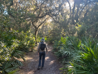
After our hike, it was time to depart. We found that when the sun was warm, the dinghy tank still wept fuel. If I jammed the fuel line into the tank (while driving) it didn’t weep as badly. (We really, really need to fix this.) I don’t have a good solution on the boat because you can’t easily wrap fuel lines in tape to keep them from leaking. The fuel acts as a solvent on the adhesive.
At about 13:00 we started the engine, hauled in all 80′ of chain, and started south. Anticipated arrival in NSB is tomorrow at 08:00.
This went great for about ½ hour or so. Then. (Music cue.)
Engine issue. All hands on deck.
Mr. Lehman is slowing and speeding up. “happy-rumble-rumble-rumble-sad-lug-lug-lug-lug-happy-rumble-rumble-sad-lug-lug-lug”. Cycling through this pattern as we listen in horror. Good and straining. Good and straining.
Okay. Okay. Breathe. Option 1 is bail out: go back and try to sort this out. Hold that thought.
Review of Basic Diesel Theory (BDT™).
- Fuel
- Air
- Compression
When in doubt, blame the fuel, fuel filters, fuel tank. All of that stuff. We have a Racor dual filter. Switch the filters from #1 (outboard) to #2 (inboard, and almost never used.)
Results? No change. Happy-then-lugging-then-happy-then-lugging.
Air is unrestricted. Compression doesn’t cycle. It’s there or the cylinder simply doesn’t fire. This isn’t a misfiring cylinder.
Consider option 1 again. Go back, but maybe to Fernandina where we might be able to get a mechanic.
Okay. Stare at the engine some more. Throttle linkage? Nope. Shutoff linkage? Nope.
Hm. Hm. Hm. Bang head on wall.
Okay. Time for advanced Diesel Theory (ADT™).
- Load
What can make the load on the engine vary? Something wrapped on the axel or prop? No. All our lines are aboard. We’ve wrapped lines on the prop twice, and we don’t get lugging. We get pounding and shaking as the line flogs against the hull.
CA notes the RPM’s are all over the map. This is a hint. The Alternator provides the RPM feed for the binnacle. More specifically the ARS-5 regulator provides the feed from the alternator.
It must be the only other thing connected to the engine. The Alternator. The Alternator is dying. It’s 10 years old and it’s already dying. I have a spare. We can cope. Here’s the tentative plan: go back, swap it out.
First, however, let’s gather data.
The Balmar ARS-5 voltage regulator has a display that cycles through a bunch of details. If there’s a problem, the display will list the part that’s not working. (Years ago, I set the regulator to use “long form” display with ALL the details.)
I sit by the engine and write down what it shows.
BAL A-5, Fdc, 10-0, -F-, bv 134, Cv 134, B1 nc, AL nc, FE 015, r 15, SP 30C, SLP 060, Hr 466 10, FbA 065, FFL 065, E 15, E 11
Generally, it’s working. BAL A-5 is the version. FdC is flooded cell. The two error codes at the end (E 15 and E 11) are missing sensors, not failures. The -F- means it’s in float charge mode; we went through bulk and absorption already. The FE 015 is the amount of energy in the field coils used to generate power. This FE value changes on each cycle through the messages. This means the load on the alternator is fluctuating.
After staring at the controller, I glanced at the ammeter on the power panel. I see —3.5A: an alarming thing. It means the engine is not producing enough power to run the chart plotter and radio. In float mode it should be 1 or 2 A above demand. Always.
Okay. Option 1 of bailing out is looking better and better right now.
What do we know? We know the alternator is not producing enough power. I think the lugging might be when the alternator goes on. And the happy rumble is when the alternator goes back off.
This means I need gather more data on why it’s cycling. I watch the ARS-5 cryptic message stream a few more times.
This is when I observed the FE change. I look back at the ammeter. I see +2.3A.
Wait.
What? Now it is producing enough power? A minute ago it was not?
What the heck!?! Hey, ARS-5, why you cycling the alternator on and off? Give me one good reason!
The Inspiration
I think I’ve found a culprit: the solar charge controller could be creating confusion. Two of the panels are new, which means I’ve added 110W of power to the existing ~300W of panels. (Also, the new panels have proper diodes, making them much less likely to be burned out by the alternator or being in the shade.)
If the batteries are already being charged from the panels, the alternator doesn’t need to do much work. If the solar panels are not charging, the alternator needs to do extra work. This may be what we’re seeing: a dispute over battery voltage. Each controller is seeing voltage levels high enough that it shuts down. Then the voltage drops and they both kick back in, only angry. A kind of head-to-head, “If you won’t, I will!” brawl.
I turn off the solar panels. Engine evens out. Solved. New line in the Standard Operating Procedures (SOP): no panels while motoring. Makes sense.
This also means that it's entirely possible the previous panels — without proper diodes — were being baked by the alternator. It’s hard to say what — exactly — the solar charge controller used to do when the engine was running.
We’ve been working our way south with the new panels for weeks and weeks. Why now? What changed? Is it really the brighter, more direct southern sunshine? We’ve moved about 10° of latitude S since October. The sun, too, has moved from its low on Dec 21 of about 30° elevation at noon (in the Alligator River) up to about 46° elevation at noon (in New Smyrna Beach). Maybe gaining 25° of “insolation” might be the change. Something to think about for the next 18 hours.
The Passage
The seas started at 1-2′; wind was 10-12. CA put up the Yankee so we could throttle back the engine a bit. Sometime late at night, they built to 2-3′, but the wind dropped, leaving us rolling along without any sails. It was a tolerable roll, unlike the day 2 where we decided to bail out.
18 hours of watching and sleeping. It was a good night.
CA spotted Northern Gannets well out at sea. It’s on her birding life-list as a never-before seen species. 29°09.208′N, 080°53.681′W. No picture, sadly. It’s hard to do close work, like spying through a moving camera without getting more sea-sick than they already were.
A few miles from Ponce de Leon we starting getting a DSC message to our radio specifically: Something something don’t go near, “33 CFR 165.775”. We looked it up after arrival. It’s the Cape Canaveral Safety Zone. We were headed that way, but never (as far as I know) crossed the actual boundary. No one hailed is on channel 16 or 22A to tell us to get the hell out of there before rocket parts fell on us.
The Arrival
The Ponce De Leon inlet is a sphincter-clencher. Some of the marks are missing, making it challenging to find the channel. It was a bit scary for a few moments, but the tide was still high enough that I managed to find deeper water before anything bad happened. It turns out the channel clings to the sea wall scary close. Now I know.
Looking for the anchorage means threading though the dayboards in the Sheephead Cut, something we didn’t do very well. I clipped one with a shroud. More care is required in the channel. Now I know.

The downtown anchorage is tight. Bahamian mooring kind of tight. We put out one anchor, and had a neighbor stop by to remind us that most of the boats had two anchors, which limits their swinging.
The picture is looking down over the bow pulpit. Chain going one way. Rope going the other. It means the bow can’t move much, but we can spin around this spot. Which is how all the other boats are set up — small, small circles.
We’re so used to single anchor in the Chesapeake that we often assume everyone will be swinging in a big circle. Wrong assumption. After lunch, when we finally took more careful looks at all the other boats, we saw everyone down a this end of the anchorage had a Bahamian mooring.
We slacked the Rocna, motored into the current, and deployed the backup Bruce, snugging ourself into a very narrow little circle. I still ran the anchor alarm app to make damn sure we aren’t moving. So far, 54′ from the original position, which includes 23′ of walking from bowsprit (where I took the mark) to cockpit (where the phone sits.)
We’re anchored at 29°01.6428′N, 080°55.0132′W. Water’s around 8′ deep and we have two rodes of 50′ to hold us here.
The Good News
We had a delightful passage. Solved problems. Made distance.
Bonus points:
A. It’s warm.
B. The marine supply store (North Causeway Marine) is a solid .25 mile away. We can see the dinghy dock from here. When the rains ends, I can grab a pocket full of tools, dinghy over, rebuild my fuel line and dinghy back without any more drippage.
Rain forecast for Sunday morning. Crappy weather at sea Monday and Tuesday. So. We may be waiting here for a few days. CA found the laundromat. Or take the ICW. So far, it seems good to wait. An ocean passage (even one as short as 18 hours) is hard physical labor. A day of rest is essential.

Sister Ship: Rosa dos Ventos
Context. We pulled into St. Mary’s on day 2, tail between our legs, licking our wounds. It’s warmer than Charleston, but still right cold. 4°C, I think. We’d really like to go ashore and hike around, but, we found dinghy problems.
Anchored at 30°46.255′N 081°28.264′W.

Who dinghies down the river to stop by?
Rosa dos Ventos
They’re also on their way south. The boat started in Maine. Some of it was Raj with a delivery crew. The rest has been the full family of four They’ve been chugging along south, mostly in the ICW.
That was wonderful.
It took our minds off the stupid fuel tank leak. See 2021 Southbound Phase III, Version 4 for the dinghy fuel line leak. We need parts. Ideally New Smyrna Beach. If not, maybe Titusville, or perhaps Stuart.

2021 Southbound Phase III, Version 4
Yes. I know it’s 2022. But our Red Ranger seasons work from May to May, so we’re in the 2021-2022 season.
(And. Phase III? Yes. Phase I was get to Charleston. Phase II was leave the boat for a long time to take the train to California. Phase III is get to Dinner Key. We have Phase IV-A and Phase IV-B for two alternatives after that. I suggest you can't over plan.)
We had things we wanted to do today, but they didn’t all work out. We have a problem with our fancy new dinghy.
First, however, our plans. We’re heading south. After reviewing the charts I’m not interested in heading toward Daytona from the Ponce De Leon inlet. I’d much rather go to New Smyrna Beach. It’s closer. And it’s pretty nice, if we can find room to anchor.
We’ve been to New Smyrna before. 28 Jan 2014. Here’s the picture of my little blue anchor location on my chart.
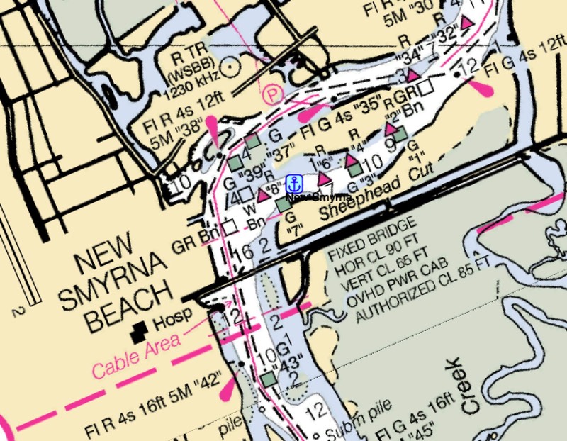
We liked it here in 2014. There was a park with a dinghy dock and a coffee shop that was a pleasant walk.
After getting pounded by wind going one way and seas going another on the 9th of Feb, we’ve got a new, new plan. We’ll start the 11th. It looks like this:
- St. Marys to Ponce de Leon Inlet (New Smyrna Beach). 114nm 18h. This will be a mid-day departure to avoid arriving at night. There’s a bridge at our arrival, which opens on the hour and half-hour; so we need to navigate accordingly when we arrive.
- Ponce de Leon Inlet to Port St. Lucie Inlet (Stuart). It’s possible to start the day with refueling at New Smyrna Beach Marina; they open at 06:00 and still make it without a risk of running out of daylight. 140nm. 23h. The alternative is several days down the ICW. It’s not bad in N Florida. (N of Jacksonville the ICW is a right awful mess because of the huge tides through S. Carolina and Georgia.)
- St. Lucie to Government Cut (Dinner Key). 100nm. 16h. NOTE mid-day departure required to avoid arriving at night.
We’re thinking that short overnighters are a sensible response to sailing in the dead of winter.
So far, the weather seems like it might be acceptable. 2-3’ seas. Mostly from the E at 7kt to start. Overnight, NE backing to NW at 2-9 knots. Saturday, NW at 8-9 knots as we arrive.
As of 13:00 on Thu10, the forecast for North Florida is this: “L&V/0-2' tonight-Sat12”. Light and variable from Thursday night to Saturday. After that, we’ll transition to the central Florida forecast area.
The New Dinghy Problem
Our fuel line leaks. The metal fitting onto the gas can has — it appears — started to fail and it dribbles gasoline. Ugh.
I had what I thought might be a spare fuel line. It came with the boat. It was at least 10 years old. It’s more likely 15 years old. The hose cracked. Broke. Like a stick. So. Nope on that.
I think I had cannibalized that fuel line when I made the new fuel line back in 2011. I’m not surprised the 10-year-old fitting has developed a drip. Since we can’t easily go ashore, we need to consider finding a marina. Maybe in New Smyrna area where we can buy a fuel line (and a spare.)
For now, we remain anchored at 30°46.255′N 081°28.264′W.

Southbound Pt. III, Day 1-2, That Hurt
The Feb 8-9 weather window was not open quite as wide as we like.
It was cloudy leaving Charleston, but flat seas and light breezes. After a few hours of motoring along, I realized we had a serious problem.
During my afternoon nap (CA’s watch) I sorted it out. For my sunset watch, I officially throttled back the speed. We we’re going to arrive too early. The breeze on our stern was pushing us to well over 6 knots, and our estimated arrival in Daytona was somewhere between 23:00 and 02:00. At 5.7 knots, we’d arrive closer to 06:00, so we’ d have some sun to see what we were doing.
I had a proper red-sky-at-night-sailor’s-delight sunset.

Boy was that misleading.
The wind crept up (We had been told it would.) This was the forecast detail I overlooked:
NNW-NNE@7-17g22/3-5' (strongest offshore) tonight-Wed9 midday
The NNW-NNE is helpful. From the north means it’s cold. That’s kind of nasty. The 3-5’ seas part was something I failed to appreciate. It was unpleasant. CA managed to get a hot meal into us. We stood our watches.
But.
It got out of control Wed morning when we tried to gybe at St. Mary’s.
Here’s the setup. The wind was from the starboard quarter. Behind us. Off the the right side. Let’s say 30° away from dead astern. The waves are more-or-less behind us, so it’s pretty pleasant to be pushed by the waves as well as the wind.
We needed to turn toward port (to the left) about 30°, bringing the wind straight behind us. The sails become more-or-less useless at that angle. So, we’re motoring along in waves that are NOT going with the wind. They’re off in their own weird world rolling from the port quarter and pushing us right over..
One of the bigger waves would roll us over onto the starboard side and we flop back, rolling all the way to the port side. Back and forth. After about 15 minutes, CA asks what changed.
I told her I’d turned and furled the headsail, nothing was stabilizing us. “I’d like to make Daytona,” I told her.
“Okay,” she replied. We knew that St. Mary’s was almost as cold as Charleston.
After a few minutes I realized we might not even make Jacksonville. The rolling made everything more-or-less impossible. All I could do was hang on.
“I’d like to make Daytona, too, but I’d like to make it in one piece,” she shouted from the companionway ladder.
Bail Out
The bail out plan was easy. We’d gybed in the entrance channel to St. Mary’s, GA. It was relatively straightforward to turn around and run right into the river and call it a day. No Daytona for us.

Here are the consequence of rolling from rail to rail.
This ancient jug of bilge cleaner — it came with the boat — dropped off a shelf and onto the passthrough. The bottom cracked clean off the container. Filling the passthrough with caustic bilge soap.
Anything else that jumped off the shelf was a mess, also.
The bag holds a bunch of things we’re going to tossing out when we get to shore.
The worst casualties were my copy of the Ashley Book of Knots. A bunch of pages got their corners soaked.

And.
My engineering log book. Started in 2010, it has every engine startup, oil change, upgrade, everything. It’s sometimes only hard-to-read scribbles.
When I want to know when the oil was changed, that’s where I look. I write down the pre-start state of Mr. Lehman every time we start. Every time. Oil consumption. Cooling water consumption. Hard-to-start. Everything.
For the most part, the edges are all that got wet, so most of the book seems usable. It’s drying in the sun. We’ll see what the caustic elements of the bilge cleaner to to the paper (I hope nothing, but… )
Anchored at 30°46.255′N 081°28.264′W.
New Plan
The New Plan is a little different from the old plan. We’re now *sure* we’re not going straight to Key Biscayne. We’re looking at three shorter one-night hops:
- St. Marys to Ponce de Leon (Daytona). 112nm 18h
- Daytona to Port St. Lucie (Stuart). 120 nm. 20h
- Port St. Lucie to Key Biscayne. 100nm. 16h
Each of these requires leaving in the afternoon and sailing over only one night. The idea is to avoid needing a huge weather window. It’s winter. We don’t have huge runs of L&V (Light and Variable) winds we can motor through.
The current forecast has this:
L&V mostly NW-NE/1-3' Fri11-Sat12
That’s our kind of sailing. Seas 1-3’ will be a delight to get to Daytona. Then we’ll wait for another day like that to jump to Stuart.

Weather Window Again (again)
There’s another big Winter Storm pummeling the northeast. Which means cold winds and high seas down here.
This has just shown up in the AMZ450 forecast for St. Mary’s, GA.
Tuesday Night And Wednesday
North winds 5 to 10 knots. Seas 2 to 4 feet.
And PredictWind has similar details.

Ah. This seems like our window. Monday’s forecast for AMZ300 (Charleston) is rain (and seas 5 to 6 ft.) But, Tuesday, there’s this: Tue NW winds 5 to 10 kt. Seas 2 to 3 ft.
This may be acceptable. The low temps are a chilly 9°C. We can bundle up. It’s the sea state we have to manage through patience.
The next zone south, AMZ454, would be the next day, Thursday, which is a little too far into the future to get a good forecast.
This fits with what I called Option 3B.
Option 3B. Two or Three irregular legs.
1. Charleston to St. Marys. 163 nm 27h. Refuel Charleston Harbor Marina.
2. St. Marys to Daytona. 112nm 18h. Refuel Port Consolidated Fuel Dock. NOTE evening departure & morning arrival.
3. Daytona to Key Biscayne. 222nm 37h. Refuel Sea Love Boat Works. NOTE mid-day departure & morning arrival.
The tidal flow in the river is slack on Tue8 at 07:50 AM. We can cast off the lines. Get fuel, and be on our way to St. Mary’s before noon. With intent to arrive the next morning or so. Call it noonish.
A 27h trip under power uses just under ½ tank of fuel. With a N wind, though, we can jib-and-jigger and maybe keep the fuel consumption down. Talking with other Whitby’s, the power consumption for night sailing (lights, computers, etc., etc.) means the engine is generally on after dark, but sometimes only at idle speed.
If the weather is benign, it’s only 18h more to Daytona. This is about ¼ tank of fuel.
It makes the total trip about 45h, which means a potential for arriving 2-3 hrs pre-dawn. If we time our arrival at St. Mary’s for noonish, we should avoid a pre-dawn arrival in Daytona. This worked out when we went for Beaufort to Charleston (See Southbound Day 28-29.) It may work out again.
&media=http://www.itmaybeahack.com/TeamRedCruising/_Media/0110bdac-445e-4c30-bdd0_1102.jpeg&url=http://www.itmaybeahack.com/TeamRedCruising/travel-2021-2022/weather-window-again-again.html "Pin It")
Running Rigging Update
We started replacing the running rigging back in September. See Home Handicrafts — Splicing for the start of this. We’re not done, but we’re close. Really close. And I’m getting better at splicing.
The start of this effort is an exhaustive enumeration of all the running rigging. Red Ranger is a double-headsail ketch: two headsails, main, mizzen, and room for a spinnaker and a mizzen stays’l. She has running backstays. I wound up with two dozen individual lines.
For Your Entertainment, here’s the list.
¼″ Lazy Jacks (2), Mizzen Outhaul
⁵⁄₁₆″ Whisker Pole Topping Lift
⅜″ Running Backstays (2), Reefing Lines (2), Topping Lifts (2), Halyards (3)
⁷⁄₁₆″ Mizzen Sheet, Halyards (2) Stays’l sheets (2)
⁹⁄₁₆″ Main Sheet. Yankee Sheets (2)
Because the headsail sheets were replaced only about 8 years ago, and are kept below during the winter, they weren’t replaced. The furling lines aren’t on this list, either.
And. We also replaced the docklines we replaced, either. They’re all ⅝″.
Inventory was Phase I. Start a spreadsheet with ALL of the lines listed.
Phase II is figure out the length. This is a riot because you can’t easily measure the lazyjacks: they go up and down on both sides of the sail and are — you know — pretty high up the mast. But not too high. Maybe half the distance to the spreader. Or so. I dunno. I went with a total of 150′ between the two of them. Turns out the mizzen is shorter than I estimated; I’ll need to measure this again.
The topping lifts, similarly, go from boom end to mast top. Times 2. Plus the length of the boom. Approximately. Pythagorean Theorem. It’s the hypotenuse of mast height and boom length times two plus the boom length. (Answer for the main is 134′.) Note that the mast height is 56’ from the water. The boom is something like 10’ above the water. So. Really. The topping lift is closer to 116′. Mizzen is something like 80′.
Most everything else is slightly easier to estimate. Sheets are easy. Halyards are twice the mast height. Reefing lines can be pulled out and measured.
Phase III was to select line. There are — of course — a million choices of weaves and fibers and vendors. Without doing a lot of analysis, I settled on NewEngland Ropes products. I bought Sta-Set lines for most things, and VPC for halyards. We don’t race. We don’t cross oceans. We’re coastal cruising lightweights. I wanted stuff I could but from Defender.com and Ropes.com.
Phase IV was to try and color-code the lines. I wanted red, blue, gold, green for spinnaker, yankee, stays’l, and main/mizzen. Halyards would be flecked, and sheets would be solid colors (or white fleck.) Other lines could be black or white. The reefing lines would be blue for the first and red for the second. This doesn’t work out well, but I came close. (The old reefing lines were white and impossible to sort out.)
Phase V is order them. When they arrived, I labeled them carefully. A box of rope was a confusing mess. Each chunk has to be positively identified and labeled before doing anything else. I wrote the purpose on the packing list, and on the tags for each hunk of line, forcing me to make a list and check it twice.
Phase VI is installation. We’re almost done. Not quite finished, but close. Really close.
What’s important is almost all of these lines have an eye spliced into them. Mostly, the eyes are pretty small, which is pleasant. In most cases, the hardware is held in place with clevis pins, which is also nice.
I’m an okay splicer. I struggle with the process. I have trouble burying the crossover as deeply as professionals do. But. I can use extra stitching to hold things in place.
Yesterday was mains’l halyard day.
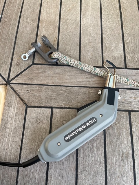
The main’l halyard has a shackle spliced on. Permanently. No clevis pin.
Step 1 is to cut the end of he halyard off. The free end of the new halyard will be stitched onto the old halyard and pulled through the mast, so the cut needs to be super-super clean. No lumps of melty line. If I was really cool, I think I’d know how to use a hammer and a rigging knife to chop it off cleanly.
Then I can cut the shackle off the halyard. I can also admire the splice. It’s a really good one with a deeply-buried crossover.

Step 2 is to do the splicing. Important: with the shackle inside the eye. This is so important I remind myself about it constantly. I forgot to include the shackle when working on the mizzen halyards. You cannot pull the splice apart. You have to cut it off to try again.
On the lower-left side, you can glimpse the paper splicing instructions from Sampson Ropes. They’re great. I like written instructions. I don’t like videos.
This went tolerably well. I was able to get the core buried without too much complaining and struggling.

Here’s my eye splice with hardware.
The blue Sharpie lines of my initial marks for the placement of the loop are visible. At some point, I should start using a pencil or something. You can kind of see the lump of buried crossover inside the cover below the splice. It’s not a perfectly smooth lump. I’m still working on my tapering and burying skills.
But it’s an acceptably small lump because the core slid over it without too much coercion.
The cover’s braid seems evenly spaced. So I got that close to OK.
One of the tricks seems to be putting the line on a winch to properly stretch it. Stretching the line slims it down, making it easier to “milk” the core over the crossover.
I didn’t take a picture of the old and new halyards stitched together. I’m getting better at creating a strong connection that can make a tight turn around a small sheave. The first time I did this, I put tape around it, also, to make sure that the sewing didn’t get caught on anything as it went around the sheaves.
I don’t seem to need to tape anymore; this went up flawlessly. It’s always a joy when the stitching goes through the block smoothly. And. When the new line pops out of the mast, you know it’s done.
I still have two halyards to go. Lines are in the V-berth. Labeled.
When we take the headsails down for hurricane season (in July, I think) I’ll be able to rework those halyards.

FYI. Here’s the 10-year-old main halyard. Note the distinct color changes. The nice, clean green-fleck where it was inside the mast. And the mildew-packed line where it was exposed to weather.
I’ve washed it in soapy water, rinsed it in clean, and ran it along the lifelines to dry in the sun for a few days. It’s still pretty useful line. The super-clean middle section, in particular, can be salvaged.

