

Some great questions. And some answers.
How much time per day / week do you spend on boat upkeep / maintenance?
I think the sailor (and writer) Beth Leonard said "Cruising is fixing your boat in exotic places."
The ocean is demanding, and mere human ingenuity isn't up to creating a vessel that can withstand the rigours of the sea.
We spend a fair amount of time puttering around the boat. While some of that time is spent drinking rum-and-tonic, a great deal of time is spent more poductively. But, what -- exactly -- are we doing?
Maintenance, generally, falls into two categories: corrective and perfective, or repairs and upgrades. We can further partition repairs into a few sub-categories. Here's how we view this overall puttering part of boating:
-
Repairs we need to do right now. These are life-critical things where failure to fix it means we're at risk of serious injury. We've managed to avoid these situations. See Crossing to Florida for our most harrowing repair.
-
Repairs we need to do before we move the boat. After Hurrican Ian, we've had a few of these. They are complete; we could launch when we return to Florida. I'd like to finish working on the running rigging, so we're not 100% ready to go. More Handicrafts
-
Repairs we should get to eventually. This means we have a work-around, and it's not all bad. We have (for example) some wiring that's not done perfectly. For another example, both sensors on the holding tank are a mess. And the entertainment system software seems hung.
-
Upgrades and improvements. This is all of the perfective maintenance. There are always upgrades and improvements. We could spend months cleaning and lubricating and polishing things that already work. Let's set those aside and focus on time we spend repairing stuff we broke.
Let's consider our last "year" living the boat: 2021-2022. We start our boat years in the spring, about 10-April-2021. It ends when we put the boat on the hard in Punta Gorda, about 18-May-2022.
Overall, here's how the months shook out: some Puttering and some Moving, and some time not on the boat at all:
-
Puttering.
-
April, May, June. Much fixing things on the boat. This includes the forward head Second (and final) Head-Ectomy. Something very important. As well as the Cribbage Board The Cribbage Board Repair. Something kind of trivial. But. We play cribbage daily; so a broken board is a serious problem. I finished my day job in May. We had an apartment for a while, then moved to the boat.
-
July and August. Land Cruise out west. Land Cruise Part IV
-
September. More fixing and upgrading. The Stove Didn't Spark Joy
-
-
Moving.
-
October to November. Moving the boat from Deale, Maryland, to Charleston, South Carolina.
-
December. Move the truck, stay with CA's aunt.
-
Janary to May. Moving the boat from Charleston, South Carolina, to Punta Gorda, Florida.
-
We'll look at the October to May voyaging separately. This is -- in part -- an answer to a question to be asked later. The serious long-distance voyaging started October 13 Southbound Day 1.
Since stuff breaks, it means stuff has to get fixed along the way.
We broke the multi-month voyage into into phases. (Otherwise, it's a bit too much to contemplate.) There were six parts:
- Get to Charleston, SC. 29 days. Starting Southbound Day 1, ending Southbound Day 29.
- Hang around. 16 days. Go back up north and get our truck from Maryland. Then go to North Carolina for December. Back to Charleston for January. Starting Charleston Time, ending Weather Window Again (again)
- Get to Key Biscayne. 53 days. Starting Southbound Ph III Day 1 & 2, ending Day 49 & 50, Key Biscayne A lot of this was spent hanging out in New Smyrna Beach. The outboard motor for our dinghy died, and we needed to replace it. This was epic because it's a logistical nightmare to get an outboard motor from somewhere to your boat when you don't have a truck. The story starts with Day 29 Problems until Day 47 Dinghy Propane. Some of the time was at a luxurious marina in Stuart, Florida, with a pool bar.
- Get to Key West. 15 days to get there. And then 11 more days of hanging out. Starting Ph IV Day 1, ending Ph IV Day 26. This phase involved repairing the mast-head light while on a buoy in Boot Key Harbor.
- Ge to the Dry Tortugas. This only a two days out and a few days at anchor. Starting Ph V Day 1, ending Ph V Day 3. When you look back on it, we spent 7 months getting here. It was great.
- Back to Florida. This is a final 18 days -- many of which were hanging out at anchor or on a mooring buoy. Starting Ph VI day 1, ending Ph VI day 18 -- Last Day
The six phases net out to 1,678.7 sea miles, more-or-less. (I use flat-earth navigation approximations and add up the distances. Yes, it's custom software I wrote in Python.) The duration is from 13 October to 18 May. Maybe 8 months, with a month or so away from Red Ranger to move our truck.
The follow-up question is "was that year typical?" The answer is each year was utterly unique. It seemed easier to pick one year than aggregate all of the log entries since 2009.
How much time do you spend...
1) parked in the slip?
This varies quite a bit. We don't always have a slip.
Some boats, of course, are a bit too fragile to be out of a slip for more than a weeked. Out boat was designed to go around the world. That might mean years outside a slip.
When we had day jobs, Red Ranger sat in the slip for months and months.
When we moved her south, she sat in a slip for a week or two in Stuart, FL, while we squared away the dinghy motor. And the rest of the time we were at anchor or fastened to a mooring buoy.
Now that she's in Florida, where slips are hellishly expensive, we're unsure what will happen. We suspect we'll try to find quiet places to anchor, and then have he hauled out for hurricane season.
2) sailing somewhere specifically?
As noted above, we spent 7 months on a long journey from Maryland to Florida. Otherwise, we barely move at all.
Since Hurrican Ian, she has not moved an inch except to be put back on the stands after getting knocked over.
In Maryland, we spent two weekends sailing around Chesapeake Bay and anchoring out. Those days count as going somewhere specific because we had an anchorage in mind.
3) just sailing around for fun for the day?
We call this "day sailing" and there are exactly three examples in the last year.
A day job limits day-sailing to weekends. Weekends mean you're looking at the weather, and -- possibly -- coordinating with guests. Day-sailing has a few complications.
What is a normal time for a trip to somewhere?
Great question. This leaves quite a bit of room to define "normal." It's like asking what size a normal dog is. Rather than use one "normal", let's look at the four kinds of trips we consider:
- Day Sails. Out and back in one day. See above for the one example in the year under consideration.
- Day Sail with Camping. Out to somewhere, drop the anchor, come back. In these cases, the duration of the sailing part is often less than 8 hours, which means less than 50 miles of travel. There were two examples in the year being examined closely.
- ICW and coastal passage-making. (ICW is what we often call the AIWW -- The Atlantic Intrcoastal Waterway.) These are broken into legs of no more than 50 miles. We hustle the 50 miles and then drop the anchor because we only go 6 knots; it's a solid 8 hours to make 50 miles. There are 28 of these passages.
- Overnight passages. These are longer passages that require us to cover a fairly long distance with continuous sailing (or motoring if the winds are light.) There are six of these. We'll talk about this as an answer to a question later on.
Other folks cross oceans. We don't. Even going to the Bahamas is essentially a day sail to get across the Gulf Stream, then drop the anchor and camp out. It's two days across the Bahamas Bank to Nassau, all done as day sails with camping.
The six offshore, overnight passages, and the significant events on each:
- Southbound Day 28-29 The Distress Flare.
- Southbound Ph III Day 1-2 Bail-Out.
- Southbound Ph III Day 4-5 Alternator Problem.
- Jensen Beach Can't Move the Anchor.
- Day 49-50 Key Biscayne Nothing Weird, which is Weird.
- Ph VI Day 1 Birb Fren.
This is how we view three categories of "normal" trips.
When sailing at night, how do you keep from collisions?
Is there some sort of detection equipment? radar? radio signal...?
We only sail at night when we're offshore. There's no safe way to transit the ICW in the dark unless you're a professional with a lot of experience, and a ton of lights.
We organize our time into six four-hour watches.
- Midnight to 04:00 Me
- 04:00 to 08:00 CA
- 08:00 to Noon Me
- Noon to 16:00 CA
- 16:00 to 20:00 Me
- 20:00 to Midnight CA
Often, we're both up the first day. CA takes her first nap during my sunset watch. I take my first nap at 20:00.
We do this to conform with the "International Regulations for Preventing Collisions at Sea", called the COLREGS. Specifically, Rule 5 "Every vessel shall at all times maintain a proper look-out by sight and hearing..."
Further, since we have a "VHF marine radiotelephone", we're obligated to monitor channel 16 at all times. (This rule is not in the COLREGS, it's a separate rule by the FCC and Coast Guard somewhere.)
Those are tbe basics: look, listen, and have the radio on.
But there's more.
There's a digital protocol used by boats over a few of the VHF radio channels (87B and 88B). This protocol announces the ship, providing COG and SOG (Course over Ground, Speed over Ground.) It also provides (at a less frequent update interval) the ship's name and the destination.
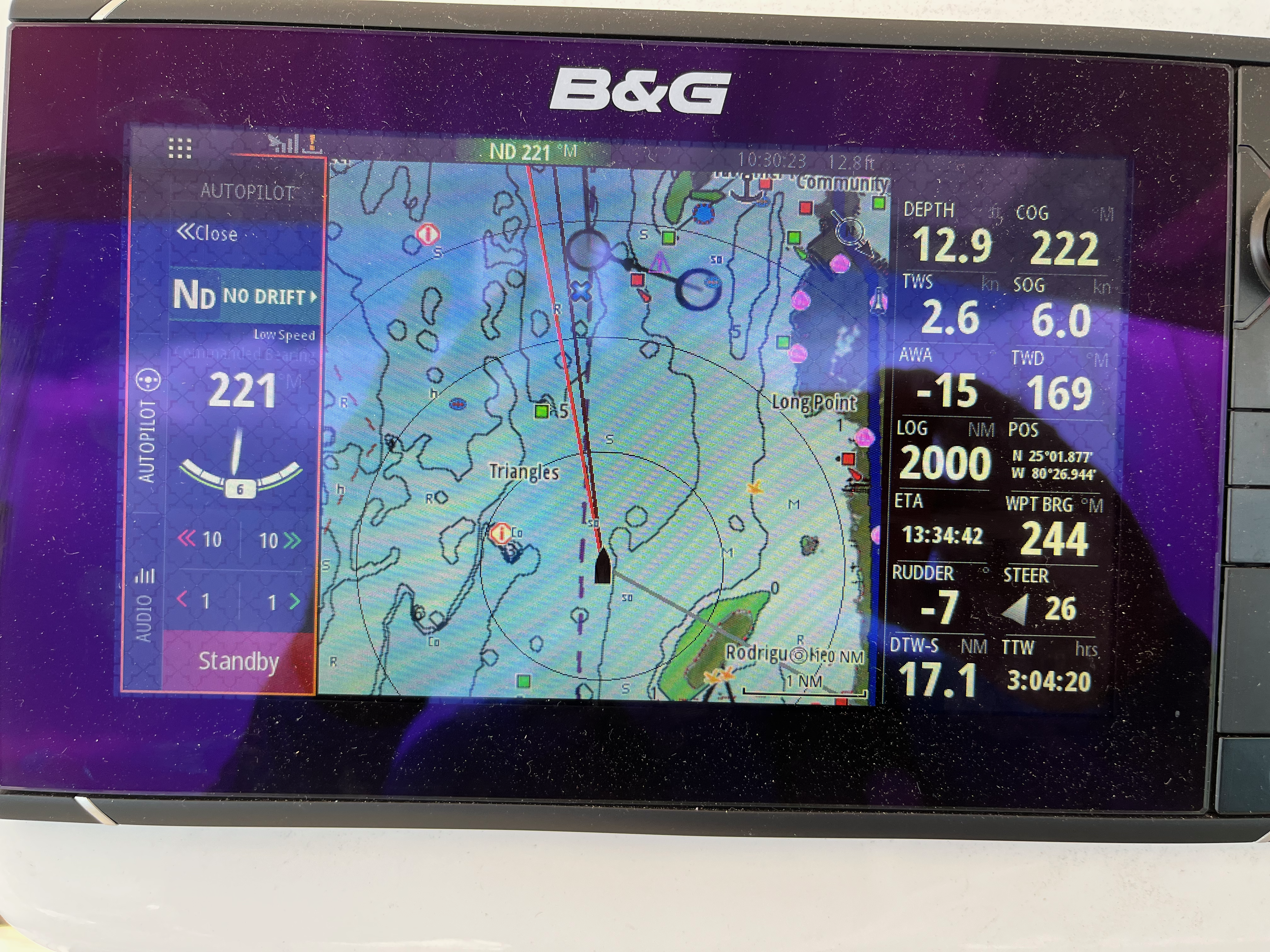
These details are presented on our chartplotter. In Real Time.
(They're also available on the radio, but the little LCD display is a giant pain in the ass to use.)
A "chartplotter" is a bit like the turn-by-turn directions app on your phone. Wayz or Apple Maps or Google Maps or whatever. The chartplotter integrates GPS data and nautical charts to show where you are and where you're headed. It can gather data from masthead wind instruments, depth sounder, speed sensor, and a magnetic compass to provide more information on the display.
(If you want to get really fancy, they offer engine instrumentation packages, also.)
You can see world-wide AIS data on Marine Traffic
You can see Red Ranger, too. Marine Traffic: Red Ranger
Currently, our AIS has been off for over a year, so the Marine Traffic web site only shows our last recorded position. (Sad face.)
The AIS reports from nearby commercial and high-rent private vessels all show up on our chartplotter. VHF radio is line-of-sight, so it's generally only ships we can actually see. Small private vessels don't have AIS, but, they also tend to stay pretty close to shore. Not always.
The military isn't big on AIS. But they're not stealthy, either. An aircraft carrier under way is flanked by destoryers and what-no. They'll radio you by name if they need to.
The harbor pilots driving container ships will also hail you by name if you're in the way. Or look like you might wind up in the way. Or if they have any reason to question your intention.
The chartplotter displays triangles and solid lines showing where the vessel will be in 10 minutes. We can see the overlaps and intersections, and steer accordingly. Or lose way to let someone pass in front of us.
(6 knots isn't our top speed, top speed is about 7.4 knots, but, you also burn tons of diesel to get past the sweet spot of max torque at 1800 RPM. So we don't often accelerate to avoid a collision.)
The chartplotter also integrates with the steering hydraulics. This means we can set a course in the chartplotter, disengage the wheel, and maintain a sharp lookout without having to hold the damn wheel for four damn hours.
We call the helmsman "Mr. Benmar." As if there's a crewmember holding the wheel. "Mr. Benmar is making 191, a point just outside the Charleton breakwater," for example. Or "I've given Mr. Benmar the full route; so you'll have to acknowledge the turn when it happens about 3 3/4 hours into your watch, if everything goes according to plan."
We maintain a paper logbook with details. Hour-by-hour. It can be helpful in an emergency -- for example -- power failure at the batteries, and all the electronics except the hand-held radio and flashlights are dead. It also give you something to do each hour. Nighttimes at sea are quiet. And dark. And -- ideally -- boring.
Sometimes, we'll have Mr. Benmar make a 10°± steering adjustment to go around something. There's a button on the chartplotter and on the control for the autopilot to make that happen.