

This week we're starting south from Belhaven, North Carolina. After Hurricane Sandy moves on and devastates the northeast.
The Commodore Says: "It may be raining, but at least it's not really cold."
The wintery cold front that merged with Hurricane Sandy brought plenty of blustery winter weather. It was cold and raining really hard. And yes, we did sign up for this.****
29th. Monday.
Anchored at 35°30.51′N 076°39.28′W
Today includes a little restowage. We rigged the WiFi antenna about bought some more Kindle edition books to read while waiting for the storm to pass. Winds are gusting to almost 25, so it's still loud and rolling around in here.

The clouds are reluctantly breaking up. Sun is trying to show. The barometer has stopped falling. Red Ranger is starting to dry out. We've logged two new leaks that require attention.
-
The hatch in the saloon has a leak around the gasket; but only when the wind is blowing and it's cold. The gasket probably dates from 1981: it's about time to replace it. We've already replaced the gasket on the forward hatch, as well as rebedding the lens. Also, we have to order gasket material from Atkins & Hoyle.
-
The vent fan in the aft cabin also develops a leak when the wind is forcing water into every little crack and crevice. This may not easily be "fixable", but we can still take the vent apart and see where the water is going when it's forced through the cracks.
We'll address these when it's warmer. And drier.
Dinner is penne with garlic and butternut squash.
Weather includes overnight lows of 6°C (43°F). Hats and polypropylene long underwear are required.
Tomorrow, we may move into Pantego Creek by Belhaven, rig the dinghy, and do some domestic chores. Laundy. Trash. Grocery shopping. Maybe Wednesday or Thursday, we'll get going south again.
Travel
| Attribute | Value |
|---|---|
| Arrive | Anchored at 35°30.51′N 076°39.28′W |
30th. Tuesday
Anchored at 35°30.51′N 076°39.28′W
Not going to Pantego Creek today. According to our instruments, it's still blowing 15-20 with gusts over 25. The NOAA weather radio warns us of the possibility of gusts to 36. Not happy with pulling up the anchor and moving the boat when its this cold and blustery.

We don't want to move the CQR anchor because it is definitely holding really well. Our red marker (known as "Floaty Ball") is proudly showing is where the anchor is. And our Anchor Alarm app is showing us that we're not dragging. After last night's gusts that physically shook the boat, that anchor is thoroughly dug into this creek bottom. Who wants to mess a well dug in anchor while the wind is gusting in the 20's and 30's?
Hurricane Sandy is moving over Philadelphia, raising havoc there. NYC has an unprecedented storm surge. We're just cold; no reason to complain.
In response to the cold, CA's closing the Dorade vents to cut down on the biting wind blowing through Red Ranger. Wi-Fi is more-or-less working, so we can continue to download books; we can also make pots of hot tea and watch DVD's.
Tomorrow the weather might be more conducive to moving into Pantego Creek by Belhaven, NC. We may not push south until Friday so that we have plenty of time to grocery shop and do laundry.
Or.
We may just run for Oriental tomorrow. We don't know the status of the various marinas. Hurricane Sandy may have done some serious damage down there. But, we think we'll give it a shot.
The point forecast http://forecast.weather.gov/MapClick.php?lat=35.506&lon=-76.654
Today: WSW wind 21 to 23 kt, with gusts as high as 36 kt. A chance of rain or drizzle, mainly before 2pm. Seas 1 ft or less.
Tonight: WSW wind 16 to 19 kt decreasing to 12 to 15 kt after midnight. Winds could gust as high as 30 kt. A slight chance of rain before 9pm. Seas 1 ft or less.
Wednesday: WSW wind 17 to 20 kt decreasing to 14 to 17 kt in the afternoon. Winds could gust as high as 26 kt. Partly sunny. Seas 1 ft or less.
CA has provisioned admirably: we have all the food, water, coffee and beer we need to handle this weather. We're running out of room in the trash area, and we need to do a load of laundry. But otherwise, we're really doing quite well.
Said goodbye to GeoNova, who was anchored about 300 yards from us in Pungo creek.
Travel
| Attribute | Value |
|---|---|
| Arrive | Anchored at 35°30.51′N 076°39.28′W |
31st. Wednesday
Cabin. Fever.

A glorious post-hurricane dawn.
Except for the Cormorants. With the lighter winds, they felt it necessary to perch on the mizzen and crap in the cockpit.

Pulling up the anchor took about half an hour because the storm had us so well dug in. Each link was packed with mud.
We motored down the Pungo River, across the Pamlico River, up Goose Creek, through some more canals, and then down Bay River.
Going up one river and then down another means the marks switch meanings on you. First you're Right-Red-Returning. Then, suddenly, you're Left-Red-Going Out.
Finally, we went down the Neuse River. The wind from the SW was brisk, right on the nose, and built up some impressive waves. Red Ranger was throwing spray everywhere. Picturesque. Exhausting.
It's good to have the hook down.
Started 35°30.51′N 076°39.28′W
Motored to 34°58.34′N 076°35.11′W
Time: 7 hrs. Distance 32 nm rhumb. ICW Mile Marker 180.

We've run almost to Oriental, NC. We stopped just 4 miles short in South River. That way, we can run over to Whittaker Creek Yacht Haven first thing in the morning and maximize our dock time.
-
Laundry.
-
Grocery Shopping.
-
Showers.
-
Perhaps I'll put on my big boy pants on and address the main water circulating pump. It's dripping (slowly). We've been putting about a pint of water into it every 20 or so operating hours. I've got the replacement in a box, ready to go. I just have to drain the coolant, dismantle parts of the engine, replace the pump and restore the coolant.
Eventually, we're heading for Beaufort and Moorehead City. There we have to decide if we're going Outside or Inside to Masonboro. The issue is Camp Lejeune and the lack of good anchorages on some pretty long stretches of the ICW.
Travel
| Attribute | Value |
|---|---|
| Depart | Started 35°30.51′N 076°39.28′W |
| Waypoint | Motored to 34°58.34′N 076°35.11′W |
| Time | 7 hrs. |
| Distance | 32 nm |
1st. Thursday
A bad day.
In the early morning light, CA looks toward the channel we follow to leave South River. She says "What's that red buoy? I don't remember that." Then she looks forward and sees that our red anchor marker ("Floaty Ball") is gone—jumped ship—ran off.
It's drifting away and is in the channel, heading toward the shallows on the other side of the river.
Damn.
There went our early start.
Rig the dinghy to retrieve Floaty Ball. This is, BTW, the first time we've rigged our totally new dinghy. And the first time we've used the motor since Carlton Moore rebuilt it for us. That part of the day was a total success. The dinghy (80 lbs instead of 110 lbs) was easy to deploy. The motor worked delightfully, the dinghy felt solid and handled well.
How did Floaty Ball get away from the anchor to which it's normally attached?
The shackle on the crown of the anchor had unscrewed itself. Really. Unscrewed. Itself.
Replacing the shackle is trivial. Adding a piece of stainless steel seizing wire to keep the stupid pin from unscrewing is (apparently) necessary.
Once we're done with that, we can head to Whittaker Creek Yacht Haven. It's no longer "first thing in the morning." It's now about 9:30-ish and we'll get there at 10:30 at the earliest.
Started 34°58.34′N 076°35.11′W
Motored to... well... It's complicated. Actually, it's unpleasant to dwell on the details.
But here they are.
Motored to 35°01.69′N 076°40.95′W—which is hard aground, just outside the channel to Whittaker Yacht Harbor. Knute was helpful and positive and supportive. But we were totally buried in the soft mud.
Got towed to 35°01.88′N 076°40.96′W. Sigh. These things happen.
It took the Tow Boat guy 45 minutes to pull us off the mud bank. Hundreds of dollars to our BoatUS policy with unlimited towing.
Time: 2 hrs. Distance 6 nm rhumb. ICW Mile Marker 180.
Okay. Now we can get stuff done. Laundry. Post Office. Groceries. Un-batten-down after the hurricane. Put the cushions back into the cockpit. Put the bimini back on. Put a new shackle on Floaty Ball.
Dinner at The Silos on rt. 55E. Maybe a mile or so walk. The Great Value grocery store is on the right as you leave the residential section. West Marine express is next door. The Silos restaurant is across from West Marine.
Showers. Ahhh. It helps to wash away the stink of running hard aground in a marked channel.
Tomorrow: Some sewing on the dodger; maybe more shopping; the engine circulating pump; top off the diesel. Then Saturday, we can run the 20 or so miles to Moorehead City and straight out into the Atlantic for an 80-mile overnight sail to Wrightsville Beach.
Generally, we sail at about 5-6 knots; getting to 7 or more is reserved for daylight hours only. The trip across the Onslow Bay is 70 to 80 nautical miles. This leads to a 13 hr to 18 hr sail. The earliest possible arrival during the day is 7AM. (Tides matter, so we may have to juggle that a bit.) Arriving no earlier than 0700 means means leaving the Beaufort Inlet about 1800. If we had good wind, and made 6 knots all night, we'd arrive after 7AM with comfortable amounts of daylight to find our way around. If we had a head wind and motored, we'd arrive around noon.
On the 4th: 10:51 AM EST 4.09 feet High Tide. An earlier arrival means we come in with a flood, a good thing. A later arrival means we bash against an ebb, unpleasant.
We would be going through NOAA marine forecast zones AMZ158 and AMZ250. Currently, the Saturday and Sunday weather looks pretty benign. The Sunday weather would be (potentially) right on the nose for the last few hours.
Coastal waters from Cape Lookout to Surf City NC out 20 nm (AMZ158)
Sat: NW winds 10 to 15 kt. Seas 2 ft. Dominant period 6 seconds...increasing to 13 seconds in the afternoon.
Sat Night: NW winds 5 to 10 kt...becoming W after midnight. Seas around 2 ft.
Sun: SW winds 5 kt...becoming N in the afternoon. Seas around 2 ft. A chance of rain in the afternoon.
Coastal waters from Surf City to Cape Fear NC out 20 nm (AMZ250)
Sat: NW winds 10 to 15 kt. Seas 2 ft.
Sat Night: W winds 10 kt. Seas 2 ft.
Sun: S winds 10 kt...becoming W in the afternoon. Seas 2 ft.
We'll monitor the weather tomorrow. If it doesn't continue looking so good, maybe we'll hang out in Beaufort, and try again later in the week.
Travel
| Attribute | Value |
|---|---|
| Depart | Started 34°58.34′N 076°35.11′W |
| Waypoint | Motored to 35°01.69′N 076°40.95′W |
| Arrive | Got towed to 35°01.88′N 076°40.96′W |
| Time | 2 hrs. |
| Distance | 6 nm |
2nd. Friday
Docked 35°01.88′N 076°40.96′W
Tried to repair the dodger. Decided that it was too difficult to repair. It needs to be replaced. We've got some contacts from the Whitby-Brewer Rendezvous and the Annapolis Shailboat Show for some nice, sturdy dodgers.

Replaced the main circulating pump on the engine. While this is a relatively easy job, it has the potential to be very, very messy. In our case, it got very, very messy.
Draining the engine block is not a pleasant job. Last time I did it (to replace the alternator) I had a nice piece of hose and a clear shot at a bucket. This time (with the new alternator in the way) there's no clear shot and it takes forever to drain the engine. I got bored of waiting.
So, when I took the pump off, about 2 gallons of antifreeze poured down into the bilge. Yikes.
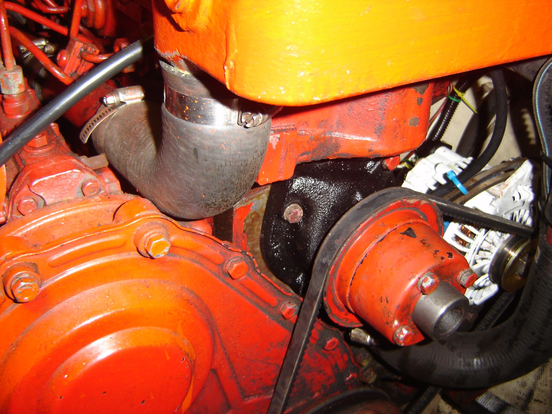
After replacing the pump, I used a bailing sponge to soak up the anti-freeze. I filtered it through about a million paper towels. I poured the clean antifreeze back into the engine rather than try to figure out how to dispose of it.
Theoretically, I should totally clean and flush the whole system. But I worry about disposal of anti-freeze.
I topped off the amount that was lost (less than a quart) with plain old water.
Ran the engine to test. No drips. I think I did it correctly.
But. No time for shopping or anything else. That will have to wait until tomorrow.
And that blows the Saturday-Sunday weather window which looked so nice.
Dinner at M&M's Cafe with the crew of Blind Faith. They were in Deltaville with us. They spent the hurricane in Washington, NC.
Travel
| Attribute | Value |
|---|---|
| Arrive | Docked 35°01.88′N 076°40.96′W |
3rd. Saturday
Anchored 35°30.34′N 076°39.22′W
This morning's forecast looks acceptable for a Sunday-Monday run to Masonboro Inlet. The crew of Blind Faith suggested that one of the big determining factors for good weather is sea state: 3-4' seas is about the limit.
Coastal waters from Cape Lookout to Surf City NC out 20 nm (AMZ158)
Sun: E winds 5 to 10 kt...becoming S 10 to 15 kt in the afternoon. Seas 2 to 3 ft. Dominant period 12 seconds. A chance of rain... Mainly in the afternoon.
Sun Night: NW winds 5 to 10 kt...becoming N 10 to 15 kt after midnight. Seas 2 to 4 ft. Dominant period 12 seconds...decreasing to 6 seconds after midnight. Rain likely.
Mon: N winds 15 to 20 kt. Seas 2 to 4 ft. A chance of rain... Mainly in the morning.
Coastal waters from Surf City to Cape Fear NC out 20 nm (AMZ250)
Sun: S winds 10 to 15 kt. Seas 2 to 3 ft. Scattered showers.
Sun Night: W winds 10 to 15 kt. Seas 2 ft. A chance of rain.
Mon: N winds 10 to 15 kt with gusts up to 20 kt. Seas 3 ft. A chance of rain.
We could get fuel early Sunday afternoon at Town Dock in Beaufort. Try to relax for a while in the later afternoon. Then hustle out after an early dinner.
Last time we sailed overnight we did 4-on, 4-off (CA 2000 to 2400; Me 2400 to 0400; CA 0400 to 0800) and we arrived safely. We could anchor behind Wrightsville Beach and rest up.
Today, we'll do some more provisioning. The big jobs are done (pump) or set aside for later (dodger). The starboard water tank really needs to be cleaned again. We'll wait until we empty it.
I fiddled with out SPOT Tracker page: Team Red Cruising. This has a week's worth of messages saved on it, showing places we've been.
Dinner was a Potato-Butternut Curry.
Travel
| Attribute | Value |
|---|---|
| Arrive | Anchored 35°30.34′N 076°39.22′W |
4th. Sunday
Got a leisurely start this morning. A quick motor across the Pamlico river, up Adams Creek, through the canal and down the Newport River (?) to Beaufort, NC. Beaufort is totally cute with a great waterfront.
Dockage, however, is $2.30 per foot. That limits how long you want to try and stay here. The creek is packed with boats and has a 180° current swing when the tide shifts. There are mooring balls, which seem better to us because we're not skilled in judging our swinging circle.
Started 35°30.34′N 076°39.22′W
Docked at 34°42.94′N 076°39.86′W
Time: 4 hrs. Distance 19 nm rhumb. ICW Mile Marker 205.
This was warm, sunny and—after the hurricane Sandy days and the running aground day—totally fun. This was, indeed, one of the best days of the trip. Four hours. Warmish Weather. Great location at the end of the trip.
We found a great dive bar with beer and food for lunch.
We're getting the hang of river pilotage: marks and shoals and traffic. We came into the docks almost like we know what we're doing. Getting out tomorrow will be the usual crap shoot of wind and current pushing Red Ranger around in a confined space. Think bull in a china shop.
Dinner on board Blind Faith: Chili and Cornbread.
Tomorrow night looks like fair weather for sailing to Wrightsville Beach.
Coastal waters from Cape Lookout to Surf City NC out 20 nm (AMZ158)
Mon Night: N winds 10 to 15 kt. Seas 2 to 4 ft. Dominant period 5 seconds.
Tue: NE winds 10 to 15 kt...increasing to 15 to 20 kt in the afternoon. Seas 2 to 4 ft. Dominant period 5 seconds. A chance of rain.
Coastal waters from Surf City to Cape Fear NC out 20 nm (AMZ250)
Mon Night: NE winds 15 kt. Seas 2 to 4 ft. A slight chance of rain.
Tue: NE winds 15 to 20 kt. Seas 2 to 4 ft. Rain.
A close examination of the chart shows that it's more like 60-70 nm, something we could possibly do in just 10 hours. Most of the trip is sailing a course of 243 (true). With wind from the North, this is a 120-degree broad reach. A sweet point of sail for Red Ranger—perhaps the sweetest.
However.
Aiming for 10 hours of sailing—when there are barely 10.5 hours of daylight, and we don't know the coast at all—seems a bit risky. What if we can't maintain that speed? It seems better to sail overnight so that we have a 10-hour arrival window between dawn and dusk. It seems smarter to plan to be too slow. It's far easier to slow down than to speed up if we need to adjust our arrival time.
Travel
| Attribute | Value |
|---|---|
| Depart | Started 35°30.34′N 076°39.22′W |
| Arrive | Docked at 34°42.94′N 076°39.86′W |
| Time | 4 hrs. |
| Distance | 19 nm |
This Week
Engine Hours: 13. Diesel Gallons: 40. ICW Miles: 69.
Travel
| Attribute | Value |
|---|---|
| Engine | 13. h |
| Fuel | 40. g |
| Distance | 69. nm |
