

Friends First.
We're going to rendezvous with some other Whitby folks here in St. Augustine.
Last winter we had five Whitby's in St. Augustine. This week, we're expecting to have four Whitby's in St. A.
Meanwhile, we'll do some chores and plan our big maintenance tasks for the summer:
-
Dodger. Red Ranger's dodger dates from the 80's and the fabric is so rotted we have be be careful that don't tear it every time we touch it.
-
Bimini. Attached to the new dodger, we'll get a new Bimini cover. Ideally, we'll have the aft steel arch reshaped so allow the mainsheet to move move without binding on the cover.
-
Solar Panels. Sitting on top of the new dodger, we want to put some solar panels. Our goal is to get at least 180W of panels. I'm a fan of the semi-flexible panels; they seem more durable, considerably lighter-weight and perhaps easier to install. They're much more expensive and (rumor has it) they're not as long-lived.
-
Chain Plates. The standing rigging—the stainless steel wire rope that holds the masts up—is attached to the hull via chainplates and stemhead fittings. The 10 chainplates are large slabs of stainless steel that go through the deck and bolt to "knees" molded into the hull. They're 30 years old and have probably developed small cracks. It's a job-and-a-half to dismantle the interior furniture to access four of the chainplates in the main saloon. For an older boat, it's considered prudent to replace them with newly-machined parts.
-
Water Tanks. We want to replace our cruddy tanks with nice, clean bladders. The bladders are about 60 gallons, so we'll lose 40 gallons of capacity from each of the tanks under the saloon floor. If we put a 30 gallon bladder under the V-berth, we're almost back to 200 gallons. We may be able to squeeze a 30 plus a 26 under the V-berth; that would be a gain of a few gallons.
-
Haulout and Paint. The hull doesn't need a complete paint job. Although it wouldn't hurt. The rudder, however, needs serious paint where various trapped lines flogged the paint off of it. We want to remove the forward head through-hull (which was never connected) and fill that hole. We're debating the value of the speedometer. While we rely on our GPS, a semi-mechanical speedo is a fallback in the unlikely event of GPS failures. But the speedo is often clogged with barnacles, so it requires maintenance. Scary maintenance. You remove it from inside the boat, jam a plug in the hole while water flows in, scrape it clean, and then pull out the plug and jam the speedo back in the hole.
-
Raw Water Pump. We need to replace the raw water pump. It's started to dribble water. The old-style pump had a connection to the engine that was subject to considerable wear. We'd like to replace it with the new-style proper gear that doesn't wear out as quickly.
-
Rebuild the Bilge Manifold. Currently, the three bilge pumps (and the defunct refrigerator) all fed into a complicated "Y" fitting. This needs to be rebuilt into three separate through-hull fittings. We'd like to wait until there's a West Marine or Ace Hardware within walking distance to start this job.
It's a pretty daunting list. None of them are quick or simple. We try to use the MoSCoW rules: Must have Should have, Could have and Won't have. These are all must haves: they're either "mission critical" (can't sail without them) or "safety critical" (can't sail safely without them.)
8th. Monday
Moored at 29°53.233′N 081°18.533′W, M-17, St. Augustine Municipal Marina, ICW Mile 777
Walkies for me; Runnies for CA.
Then back to the Municipal Marina for some washing—laundry, specifically.
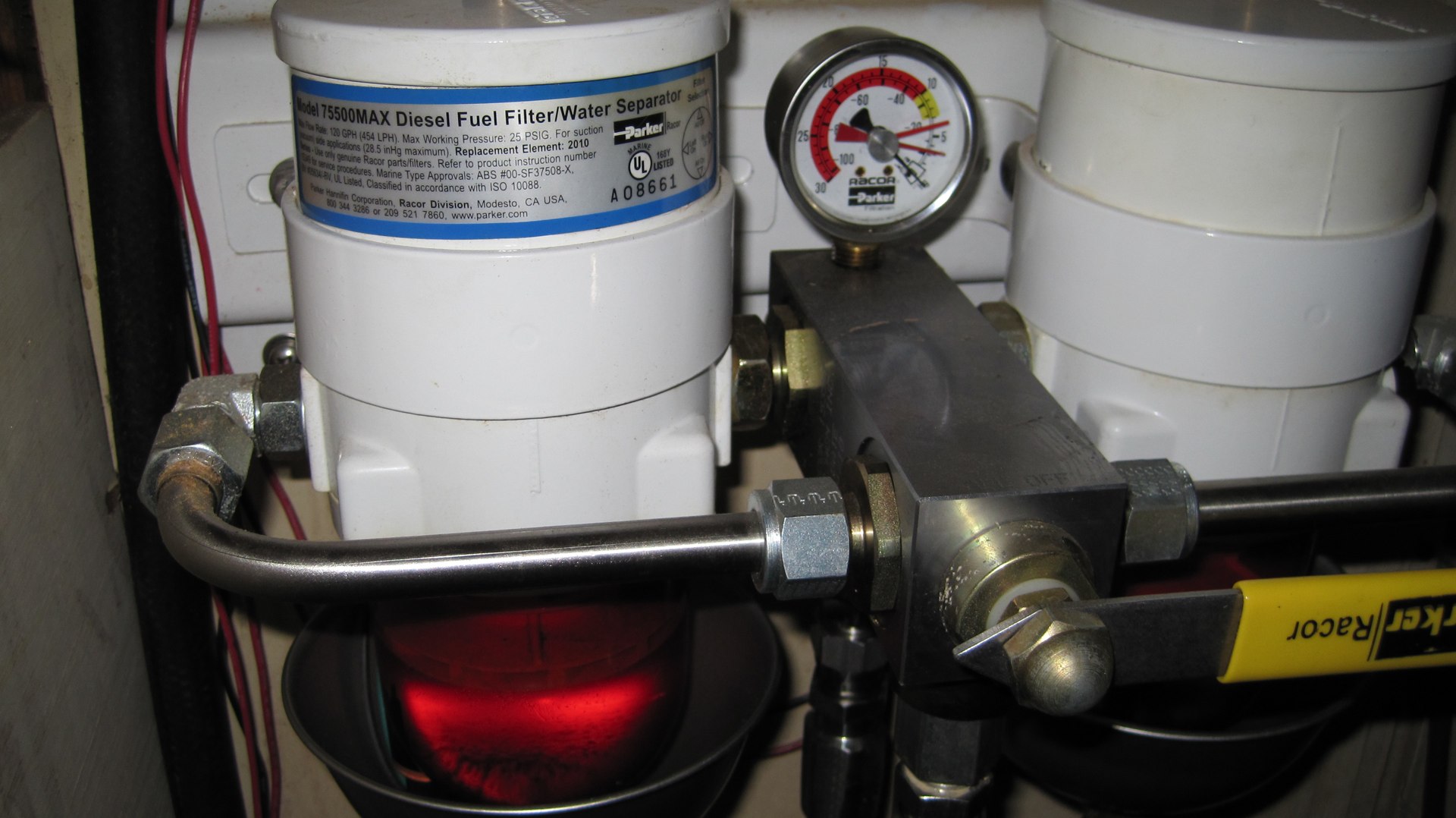
Then back to Red Ranger to replace the primary fuel filter. The vacuum pressure gauge had inched up from -3″ to -4″, indicating that fuel was not flowing at the same steady rate as it had for the last few years. Last time I did this (August 2011) the new engine hour meter showed 60.4 hrs. Today it shows 395.8 hrs: that's 335.4 hrs, 1 year 8 months, on the filter.

The bottom of the bowl on the filter assembly had a little puddle of some kind of black gooey nuggets. The nuggets were so densely packed that I couldn't drain the filter bowl. I had to jam our dental probe in there to make a space for the old fuel and goo to drain out.
Quick rinse with some fresh new diesel. Stuff in the new filter. Fill the filter housing with clean fuel. Start Mr. Lehman. Bleed the secondary filter. Let Mr. Lehman run for ½ hr. to be sure everything's ship-shape. Ah. Happy Noise. And not too much of a mess.
Tomorrow, I'll tackle the two secondary filters. They're not quite to simple, or neat. I'm hopeful that I can drain them without pouring all of the diesel down the side of the block, and refill them using a funnel so that I don't have to spend an hour priming and bleeding.
Back to municipal marina to pour out the quart of icky fuel-plus-goo from the filter change. And throw out our Waste.
And then Walkies to a quilt store to pick up some quilting supplies.
Dinner at Barley Republic.
Travel
| Attribute | Value |
|---|---|
| Arrive | Moored at 29°53.233′N 081°18.533′W |
9th. Tuesday
Moored at 29°53.233′N 081°18.533′W, M-17, St. Augustine Municipal Marina, ICW Mile 777
Walkies for me; Yoga for CA while we do Washing—yet more laundry. Only one more load today. We tend to let things pile up until we get to a really good laundry. Municipal Marina has four machines that work well and Wi-Fi, too.

I use the Wi-Fi to research solar panels. The options seem to boil down to 2 100W panels or 3 65W panels. Using two 100's leaves a gap under the boom where there's not much sun in the first place. Using 3 65's uses 95% of the top of the dodger, even if one of the panels lives in partial shade most of the time.
While we really want Solbian Flex panels, they're very expensive.
Real Work
After lunch, I changed the secondary fuel filters.
Since these are not simple spin-off filter housings, this has the potential to turn into a horrifying diesel fuel issue.
Strategic placing of an old margarine tub really helps. [We, BTW, don't eat margarine. Read Real Food: What to Eat and Why.]
I was able to open the drain cock on the bottom, open the bleed valve on the top and drain out all the fuel from the filters before taking anything apart. This fuel was spotlessly clean and bright no-tax red; unlike the fuel from the primary filter which was the color of tea with goo floating in it.
Also, using a little funnel to pour fuel back into the filter housings through the bleed screw hole helped. I opened both screws, carefully poured fuel in until it was bubbling out out of the other hole and dribbling down the side of filter into my margarine bucket. That meant that, except for small air bubbles, the filters were full.
I made a small effort as using manual level on the pump to force fuel through manually. I lost patience with this manual priming. Other Whitby folks suggest I add an electric pump to the system; a small Delphi lift pump would be nice.
Then.
Let Mr. Lehman rip. He started on the first round of cranking. I quickly bleed the last of the fizz from both filter bleed holes, and Red Ranger is back in business. Let him run for ½ hr. to be sure that more than the quart of fuel sitting in the various filters is being burned.
It's hard to tell from the picture, but the vacuum pressure gauge looks happy. There are three indicators. The top one is fixed at -5″ as in "if you're here, your filters are blocked." The middle one is the "highest seen so far" which I left near -3″. The bottom, black indicator is "current pressure" and is right on -0″. The final step is to turn the highest-so-far needle back to -0″.
New fuel line. New leak-off line. New left-side primary filter. New secondary filters. Mr. Lehman's happy noise. I feel that someday I'll almost know what I'm doing.
Busy Day
While I fooled around, CA made a new loaf of home-made bread.
And: we had hot water to wash up with.
Dinner with Creola, Joie de Vivre and Indefatigable at Harry's.

What shoe did all eight of us wear? Keens. Weird. Purple shorts, green shoe is CA from Red Ranger. Clockwise, that's Scott from Joie de Vivre, SFL from Red Ranger. Rick from Creola, Jeannie from Joie de Vivre, Carol from Creola, Carolynn and George's two from Indefatigable.
I guess they're a good deal.
The other Whitby's are all leaving here tomorrow. Indefatigable is headed S to their new home near Ft. Meyers, FL. Creola is headed north to put the boat into summer mode in Jacksonville, FL. Joie de Vivre is headed N to their summer home in Solomons, MD; their going outside to Savannah.
We're headed N, also, but we're waiting for one more mail drop before we go.
Travel
| Attribute | Value |
|---|---|
| Arrive | Moored at 29°53.233′N 081°18.533′W |
10th. Wednesday
Moored at 29°53.233′N 081°18.533′W, M-17, St. Augustine Municipal Marina, ICW Mile 777
Walkies (to The Kookaburra) for me and runnies for CA.
The birds have found our mizzen mast, so we have to wash the bird poop off the poop deck. That's our big job for the day.
Our huge, stressful engine jobs are behind us. We're looking at the long list of "little" jobs. Top of the list of "little" jobs: refinish the hatchboards. Sand. Epifanes. Sand. Epifanes. Sand. Epifanes. And more sanding and more Epifanes. But sanding means sawdust everywhere; so we want super calm conditions.
New Toys
We have some electronics to look at, also. These are things we need to order for delivery to some place where we can receive the packages. Maybe Annapolis. Maybe Deltaville.
-
Dual AMB600W Marine Bluetooth receiver to replace our legacy stereo. A bluetooth receiver means that anyone with an iPhone (or iPad) can be the DJ. The boat Liquid Therapy has this; love it.
-
Dual XGPS150A Bluetooth GPS receiver to allow computers (and iPad) to receive GPS positions. We have a wired GPS antenna for one computer at a time. The idea of supporting all computers (and iPhones) wirelessly is appealing.
-
An EPIRB for the boat. We waffle back and forth between Personal Locator Beacons (PLB's) an EPIRB for the boat. We think that our jacklines and harnesses are effective prevention; a PLB isn't necessary. A "Category II" (manually deployed) EPIRB is an ultra-reliable backup for the SPOT locator SOS feature. The ACR GlobalFix iPro seems to be the state-of-the-art.
These are relatively easy purchases. Mostly it's a matter of finding the money.
Upgrades and Replacements
At some point, I want to look at replacing Mr. Benmar (a Cetec Benmar Course Setter 21R) with a modern, GPS-based autopilot that uses a tiny fluxgate compass and integrates with our chart-plotter. One possibility is to take a control head that's designed to drive a hydraulic pump and integrate it with our existing hydraulics. Big names like Raymarine, Furuno and Simrad offer mostly complete systems; Si-Tex, ComNav and Octopus seem to offer useful components.
The other possibility is to go whole-hog and replace our hydraulics. They're "Hynautic", owned by SeaStar, owned by Teleflex. There are replacement parts available for the core steering system. That part is not obsolete, so it doesn't really need replacement.
The instruments for boat speed, depth, and wind are ancient DMI units that should probably be replaced before they fail. With modern GPS, a boat-speed indicator isn't really all that useful except as a fallback in the unlikely event of catastrophic failures. The depth doesn't include temperature, so we'd like to upgrade that. None of them are visible late at night without a flashlight: the illumination is dim and they're not located any place convenient to see. But they work now, so we need to proceed cautiously.
Thinking about new instruments raises the question of wired vs. wireless (i.e., Raymarine /TackTick). The idea of replacing the wind instrument without running a wire through the mast is very appealing. Plus there's an NMEA-MicroNet interface to allow coexistence between wired and wireless instruments, chartplotters and autopilots. The displays, while solar powered, can be recharged from boat power.
Real Work
Enough dreaming.

Today's actual chores included replacing the fresh-water filter. And restocking the beer. Plus, as long as we were out, stop by Sailor's Exchange to pick up a few things.
Beyond beer, one important thing to pick up was some crimp connectors that are blue and red.
Crimp connectors are color coded: red is 18-22 gauge, blue is 14-16 and yellow is 10-12. Below 10-gauge, they don't use so many butt connectors, and you have to get the right crimp fitting for your 8, 6, 4, or various kinds of 0 wire. At Sailor's Exchange, they have these cheap ($1.00) bags of 10 red-blue connectors. These are important because modern boat systems (like lighting) use far less current and have smaller wires than the systems we're replacing. The legacy wiring tends to be heavy on 14 gauge. Modern devices tend to use 20 gauge. Our new radio, for instance, uses 0.9A when receiving. Our old GX1250 radio uses 1.5A when receiving. A red-blue crimp can simplify life; it means we don't have to replace the wire all the way back to the connector block in the engine room.
CA picked up some more quilting supplies: batting and an hoop. She saw a suggested theme in a quilt magazine: "Passages." We've had a few of them, both overall lifestyle passages and voyages. And a Whitby has a passage from the saloon to the aft cabin.
Dinner was some alu matar, another tomato, cheese, basil salad and some homemade bread.
Departure
Time to knuckle down and start planning the northward hops.
-
St. Augustine to Charleston: 183 nm, course of 034°, 36 hrs sailing. Leave St. A about 1800, sail two nights to arrive some time after 0600.
-
Charleston to Beaufort: 200 nm, course of 066°, 40 hrs sailing. Leave Charleston about 1400, sail two nights arrive sometime after 0600.
We could leave as early as Friday, making the Charleston leg traveling Friday, Saturday and Sunday.
Friday we're in AMZ452: South winds 15 to 20 knots. Seas 3 to 5 feet. Inland waters a moderate chop. Scattered showers and thunderstorms.


Friday Night, we're in AMZ450: West to northwest winds 10 to 15 knots.


Saturday AMZ354: SW winds 5 kt...becoming NW after midnight. Seas 2 ft.


Saturday night AMZ352: W winds 5 to 10 kt...becoming NW after midnight. Seas 2 to 3 ft.


Sunday we're in AMZ350: E winds 5 to 10 kt. Seas 2 to 3 ft.
This looks like benign motor-sailing. The wind switches from SW 5 kt. to NW can mean that the wind as to die completely before building in the new direction. It might be more pleasant than our crossing from the Bahamas.
Travel
| Attribute | Value |
|---|---|
| Arrive | Moored at 29°53.233′N 081°18.533′W |
11th. Thursday
Moored at 29°53.233′N 081°18.533′W, M-17, St. Augustine Municipal Marina, ICW Mile 777
Walkies (to The Kookaburra) for me and Yoga for CA.
CA emptied the Nature's Head, walked to Stewart's and the consignment store near Stewart's for some shopping. Mostly fresh produce and eggs.
We got our final mail drop. Finally. Legal documents received, signed and sent along on their way.
Wind this afternoon was at least 25 kt, sometimes gusting higher here in the Matazanas river. Breaking waves over the docks. Spray over the bow of the dinghy. Nasty. We took our groceries as far as the fuel dock and turned around and went straight back. Our groceries had a big day out, going to the coffee shop for a snack and then to Meehan's for drinks.
Dinner at Meehan's with the St. Augustine Cruisers. Michelle explained why she and Tony started the cruiser's net. They had moved from Austin, TX, leaving a very active group of lake sailors. They had chosen St. Augustine because it had very similar demographics to Austin with the added bonus of ocean sailing. But. One thing St. Augustine lacked was a tightly-knit sailing community. So that's what they're creating here.
I'm so glad I turn the radio on at 0900 channel 72 to listen in. And we're glad we friended the St. Augustine Cruiser's Net Facebook page.
Weather looks a bit sporty for going outside tomorrow. Other folks at the Cruiser's meetup suggest we don't try the 5-foot seas, but consider motoring up to Jacksonville. Saturday's weather will be better. The current weather is part of a meso-cyclone system blasting across the US spewing tornados.
Travel
| Attribute | Value |
|---|---|
| Arrive | Moored at 29°53.233′N 081°18.533′W |
12th. Friday
Moored at 29°53.233′N 081°18.533′W, M-17, St. Augustine Municipal Marina, ICW Mile 777
Today's weather word?
"Sporty." Still.
Not as sporty as yesterday afternoon. But still too sporty for a pleasant trip.
CA called it when we looked at bringing Scout (the dinghy) aboard. It was blowing too hard to safely haul her in. It would have meant wrestling 60 square feet of wind-catching rubber onto the deck in winds that were rarely below 15 kt and gusting into the low 20's.
Confusingly, it's delightfully warm. And the sun keeps trying to peek through the clouds.
And we've been in worse weather. We can go under these conditions.
For short periods, the wind drops below 10. The 0900 bridge opening horn calls out to us: Hoooooot hoot, "you could have started earlier" and "move it."
From Song of Ice and Fire: one long means Rangers returning to The Wall; two long means Wildlings; three long means Others. A boat overtaking another signals "one whistle" for passing their starboard side or "two whistles" for passing the other boat's port side. They say this on the radio, "Red Ranger, we're going make a slow pass on your two." We answer, "Port side, roger." The bridge does one long one short when it opens. Five short when it closes. Big boats will do three short when backing up. One long means departing a dock or moving around a blind turn.
The Bare Minimum
If we go inside, we only need to go from mile marker 777 to a good anchorage at mile 739: 38 statue miles, about 5 hrs, less with a tailwind. We could probably have made Fernandina at mile marker 716 if we had started earlier. That's only 61 statue miles, 8-9 hrs of chugging.

Then it gusts to 20 again.
Got you, Poseidon: ICW: It Can Wait.
Then the breeze slacks and we wring our hands some more.
Then it gusts and we decide that we've already made the right decision.
Then the sun pokes out. Or the bridge horn sounds its greeting as it opens.
Jumping outside from Fernandina makes it 29 hrs to Charleston. Much nicer than jumping outside from here. One night plus a few hours of daylight.
Jobs For The Day

CA's working on a permanent dinghy motor cover to keep the salt spray off the dinghy motor housing. It's not mission critical. But it's very nice to have a spray cover to protect it. One that fits under the strips we use to raise and lower it. Our current cover has to be removed to use the motor.
I'm looking at charts and weather forecasts. Zone AMZ450 (off Fernandina Beach), for example.
**Sunday**: Southeast winds 10 to 15 knots. Seas 2 to 3 feet. Inland waters a light chop. Scattered showers and isolated thunderstorms.
Okay. That would be fun sailing. That's why we're waiting.
And. we're waiting because at 0930 it was a bit too breezy to safely retrieve Scout.
By 1500, however, the wind had settled down to a reasonable level in the 10's. Tomorrow and Sunday should be nice motoring up the ditch. Then (if the weather holds) we can do the 24-hour trip to Charleston on Monday, arriving Tuesday.
Dinner was the last of the alu matar.
By 1900, the wind was down to a gentle 5 or so knots. Dinner dishes washed. Most of our toys are put away for tomorrow's trip.
Travel
| Attribute | Value |
|---|---|
| Arrive | Moored at 29°53.233′N 081°18.533′W |
13th. Saturday
Started at 29°53.233′N 081°18.533′W, M-17, St. Augustine Municipal Marina, ICW Mile 777.
Big Day. Lots of things went right and lots of things went wrong.
Got 48 gallons of diesel. Topped off the water. Came onto the dock like we knew what we were doing. Mostly because we followed the dockmaster's instructions.

Passed our mentor, Michael T., of Wind in the Willows. We had been briefed by Michael on how to get to the Bahamas and back. He leaves Deltaville more-or-less on October 1st every year. I'm not sure when he leaves Georgetown in the Exumas, but on April 13th, he was in St. Augustine, heading north with us on the 08:30 bridge opening.
We chugged up the Tolomato river, down Pablo Creek, across the St. Johns river, up Sisters Creek and down Sawpit Creek. The bridge on Sisters Creek (like the FB Knox Bridge) is an open-on-demand bridge with bridge keepers who can time your approach. I didn't even have to slow down.
On Sawpit Creek, however, things changed.
For the worse.
Groundings
A boat we'd talked with in St. Augustine was hard aground in the middle of the creek between marks R48 and G49. Tide is falling, and they're stuck hard. They have few options. The tide won't be rising until almost nightfall. They can't try to navigate the river in the dark. All they can do it put out anchors. Around dawn tomorrow it will be load tide. Again. They'll have to wait until later tomorrow afternoon when they get a high tide during daylight.
CA spotted the green marks we needed to go around. So she drove us past that sand bar flawlessly.
Tide is still falling in the South Amelia River, and just south of R42, in water charted to be 11 feet deep, we hit a sand bar that was only 5 feet deep. 30°33.092′N 081°28.097′W. We bumped to a halt in what appeared to be the middle of the river. As near as I could guess the channel was to our right, and the only way to get there was to rev up Mr. Lehman until we were plowing our own channel back toward deep water.
In this case, R42 needs to be moved further south, or a buoy needs to be added to show the south end of the shoal.
Tide is still falling and we've only gone another two miles or so, and—again—we're in water that's too shallow. Again. 30°35.651′N 081°28.835′W. This time, however, I had been watching the depth more carefully as we came around the bend; I took the engine out of gear when I was unsure where the deep water was. Rather than plow our way deeply into a sandbank, we drifted into it. With some patience (and a lot of RPM's) I was able to back off the shoal and out into the channel. This time I tried the other side and found deep-enough water.
In this case, some red-side marks would be handy to show the where shallows are.
Once we got to the cut that leads to Kinglsey Creek, the marked channel was a lot more forgiving; it maintained its depth for most of its width.

Once we passed the junction between Kinglsey Creek and the Amelia River, we dropped the anchor near the oyster beds and stopped. Two groundings were enough for us. Pressing on toward Fernandina seemed like too much work.
At low tide, we had 7′. At high tide, we expect 12′ or more: lots of chain plus big Rocna means a good night's sleep.
Anchored at 30°38.383′N 081°29.500′W, Amelia River, near Fernandina Beach, ICW Mile 719.
Dinner was sweet potato with chickpeas curry.
Offshore Weather
While tomorrow, Sunday, is predicted to have great sailing weather during the day, Sunday night is supposed to turn into heavy going: 4-5' seas near shore, 5-8' seas offshore. Okay. We don't want to make an overnight offshore passage from Sunday through to Monday.
Weather for Monday and Tuesday is light and variable winds. We can motor sail through that. It will be flat seas and no bridges or shallows.
For now, the plan is to head offshore for a day sail up to St. Simon's Sound. That's only 30 or so miles, 5-6 hrs of sailing. We'll anchor, wait for the expected squalls Sunday night, and then start out Monday for Charleston (or maybe Beaufort.)
Travel
| Attribute | Value |
|---|---|
| Depart | Started at 29°53.233′N 081°18.533′W |
| Waypoint | Grounding at 30°33.092′N 081°28.097′W |
| Waypoint | Grounding at 30°35.651′N 081°28.835′W |
| Arrive | Anchored at 30°38.383′N 081°29.500′W |
| Time | 10h 10 m |
| Distance | 58 nm |
| Maintenance | Took on 48 gal diesel |
14th. Sunday
Started at 30°38.383′N 081°29.500′W, Amelia River, near Fernandina Beach, ICW Mile 719.
Chugged out the St Mary's Inlet. The last time we did this (heading S, week 12) it was nasty and sloppy; we had a perfectly awful trip to St. Augustine. Today, it was flat and pleasant. Grey and overcast, but otherwise flat. A light breeze we thought we could sail with.
Once into the Atlantic, we turned North and hoisted some sails.
There's nothing like an offshore sail to cleanse the grit of groundings from your teeth.
The wind, however, was only about 30° off our course, so the sails were essentially useless for the first few hours. We put up mizzen, main and stays'l; looked over our trim, and struck the mizzen and stays'l right away.
CA did the kneadful and baked bread. While we were underway. A first.
I sat at the wheel and watched. I managed to get a good balance between mains'l and engine and motored North at a pleasant clip while she baked.
About noon, the wind had clocked a bit further East, and we could pull out our yankee and stays'l and bang along at a better clip with no engine. Real Sailing! No Engine!
Wind Shift
We were sailing wonderfully for about 30 minutes. Maybe forty five.
Then the wind died.
What does the sailor do when the wind dies suddenly?
Does he press on more canvas to make as much as a can from the last gasps of the dying wind?
Or does he say "Damn it!" and start the engine?
Often, when the wind dies from one direction, that means it's being opposed by a wind from the opposite direction. Considering the predictions for nasty weather this evening, we elected to scrap the sails rather than try to coerce more speed by pressing on more canvas.
It was grey. We could see storm clouds over the land. The NOAA weather radio announced a tornado watch for bit of offshore water between the Altamaha Sound and St. Augustine. The exact bit of offshore water we were chugging through.
Of course, it rained. We mostly expected that. We heard thunder, but—luckily—saw nothing scary.
We spent two hours working our way up the river past St. Simon's Island to a pretty snug spot near marker 7 in the Mackay river.
With luck, the bad weather will pass us by.
Anchored at 31°09.571′N 081°25.329′W, Mackay River, near St. Simon's Island, ICW Mile 677.
We made good about 42 miles as measured along the ICW in 9 hours. By going outside, we avoided groundings and bridges.
Dinner was eggplant in a spicy tomato sauce over elbow macaroni.
Offshore Weather
It's now 124 miles to Charleston. 25 hours. The four weather zones to Charleston look like this:
AMZ450 Monday: Southwest winds 10 knots becoming southeast in the afternoon. Seas 2 to 3 feet. Inland waters a light chop. Scattered showers and isolated thunderstorms in the morning. Isolated showers and thunderstorms in the afternoon.


AMZ354 Mon: W winds 5 to 10 kt...becoming S in the afternoon. Seas 2 to 4 ft. A slight chance of tstms. A chance of showers...mainly in the morning.


Mon Night: E winds 5 to 10 kt. Seas 2 ft.


AMZ352 Tue: NE winds 5 to 10 kt. Seas 2 to 3 ft.


AMZ350 Tue: NE winds 10 kt. Seas 3 to 4 ft.
Essentially motoring weather. The Tuesday forecast means tedious motoring into head seas for a while. A run up the river to Charleston, however, would make the NE wind less odious.
If we were to keep going—another 112 miles NE to Cape Fear—we'd have weather that looks like this:
AMZ254 Tue: NE winds 10 kt. Seas 3 ft.


Tue Night: NE winds 10 kt. Seas 2 to 3 ft.


AMZ252: Tue Night: NE winds 10 kt. Seas 2 to 4 ft.


Wed: NE winds 10 kt. Seas 3 ft.
A painful 24 dead-into-the wind slog. No thanks.
If we wait a day, however, we get this:
AMZ254 Wed: NE winds 10 kt or less...increasing to 10 kt in the afternoon. Seas 2 ft.


Wed Night: SE winds 10 kt. Seas 2 to 3 ft.


AMZ252 Wed Night: E winds 10 kt. Seas 3 ft.


Thu: SE winds 10 to 15 kt. Seas 3 to 4 ft.
Wednesday-Thursday might not be so bad. Some slogging in the morning. But overnight and the next day should work out well. We can run in Cape Fear inlet and rest up in Wilmington for the next leg to Beaufort.
It's 65 miles from the Masonboro Inlet to Beaufort; that's only 13 hours. 1800 to 0700; a short overnight where we leave Wrightsville really late in the day.
Travel
| Attribute | Value |
|---|---|
| Depart | Started at 30°38.383′N 081°29.500′W |
| Arrive | Anchored at 31°09.571′N 081°25.329′W |
| Time | 8h 30m |
| Distance | ? |
This Week
Engine Hours: 19. Diesel Gallons: 38. Water Gallons: 37. Miles Run: 100.
Books: Our Kind of Traitor: A Novel. Stalking the Blue-Eyed Scallop.
Read Aloud: A Dance with Dragons: A Song of Ice and Fire.
Travel
| Attribute | Value |
|---|---|
| Engine | 19. h |
| Fuel | 48. gal |
| Water | 37. gal |
| Distance | 100. nm |
