

Bahamas!
Bound for the US of A. We're working our way back to Nassau to get provisions. Then across the Great Bahama Bank as weather permits, then across to the US. Ideally, we'd like to hit Beaufort and save a lot of ICW folderol. But. Maybe we'll hit St. Augustine and work our way back north more slowly.
We want to be in Annapolis in April, so we're not voting for slowly.
11th. Monday.
Started at 24°31.138′N 076°47.828′W, between Little Pigeon Cay and Shroud Cay
While this could have been another perfect sailing day, it was also a chance to charge the batteries some more. So, we motor-sailed for the first two hours. Then, we were less than an hour from Allens Cay, so we motor-sailed for the last hour, too.
Anchored at 24°44.961′N 076°50.276′W, between Allens Cay and Leaf Cay
Our run today was exactly 3 hrs. 12 min., 14.4 nm.
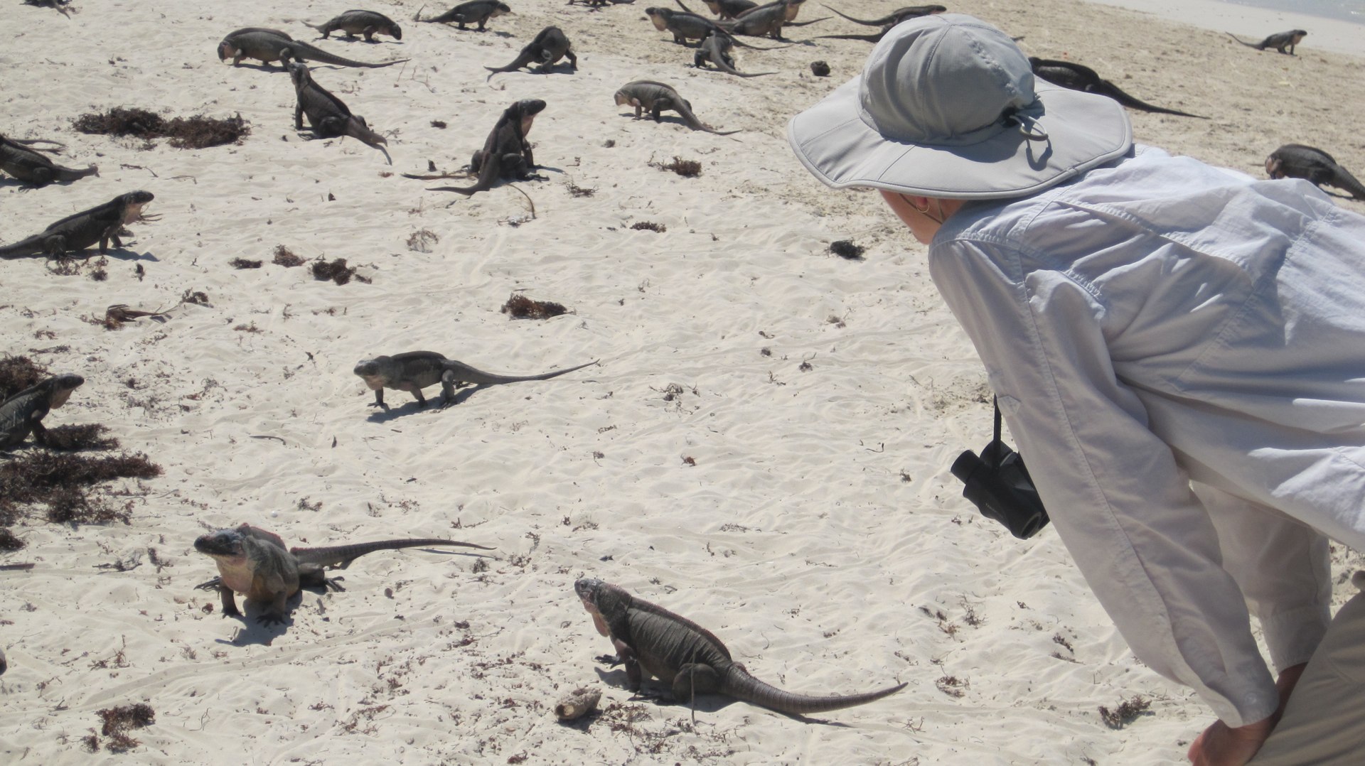
We launched the dinghy and visited the Iguanas on Leaf Cay (and Southwest Allens Cay) this afternoon. Think Jurassic Park. Yes, they're small. But they're everywhere and they're watching you. Closely.
Every little scurry in the bushes could be something really big and scary.
I reminded them: "Wallet, Cover for a Money Clip, Eyeglasses Case: I've got my eyes on all of you evil little monsters."
Dinner was farro and roasted butternut squash. While the recipe calls for goat cheese, we used yogurt instead. Yum.
Weather tomorrow looks fair for the 30 nm run to Nassau.
Travel
| Attribute | Value |
|---|---|
| Depart | Started at 24°31.138′N 076°47.828′W |
| Arrive | Anchored at 24°44.961′N 076°50.276′W |
| Time | 3h 12m |
| Distance | 14.4 nm |
12th. Tuesday
Started at 24°44.961′N 076°50.276′W, between Allens Cay and Leaf Cay

Today started with sporty conditions for broad reaching or running to Nassau. Once we were under way, the wind eased off until it was barely blowing. CA worked out a way to ease the mizzen way off the wind by removing the running backstay. That helped keep us moving.
Broad reach. Light Air. Need more sail? Call in the Mizzen Stays'l.
Unlike last week—where we thought about, but never got to it—today, we put the sail up and ran under Yankee, Main, Mizzen Stays'l and Mizzen. Without the motor running, we were making about 3+ knots at best. The air was barely moving.
With the motor turning over at about just a hair over idle speed, we could make almost 5 knots. We had a glorious low-key run to Nassau.
In the afternoon, the wind starting building until we were making 6 knots. In addition to building, wind had clocked a bit for us. We can just keep Red Ranger broad reaching at 150 relative to the wind; once the wind started coming from directly S, we could follow a rhumb-line course straight into the Eastern entrance to Nassau harbor.
After that wonderful beginning, things fell apart.
The anchoring in Nassau can be dicey. Last time we were here, we took three tries to get the hook set, because we were advised by our neighbors to use two anchors. We did, and it seemed to help. But we spent a sleepless night monitoring the two anchor situation.
Today, we screwed up royally. We misjudged the angle at which boats were hanging off their anchors and dropped our anchor onto someone else's anchor chain. What a mess to disentangle. We pulled up part of their chain and lost one of our boat hooks separating the two.
We tried a second time and dropped it too close to another chain. At least we didn't pull up this second chain.
Still. Twice. In one day. Back to back. Ouch.
The root cause? Not motoring directly into the wind or current when dropping the hook. The narrow fairway here means that I didn't get a good look at my neighbors from directly astern. I asked CA to drop the anchor based on a false impression of the spacing of the boats. Narrow anchorages are trouble. Now we know. Twice.
Then.
We were boarded by Bahamian Defense Force.
What? Did the guy who's anchor we pulled up complain?
No.
It was a routine boat inspection. Very polite. Very formal. Making sure our paperwork was in order.
Anchored at 25°04.590′N 077°18.498′W in East Channel, Nassau.
Dinner was roasted butternut squash and quinoa.
We'll be getting groceries, water and fuel here. Plus using some internet at the Starbucks.
Weather indicates that we should stay here at least Wednesday, Thursday and Friday while winds are blowing from the N and NNE. Saturday, however, winds from the E mean we can make a break for Chub Cay across the Tongue of the Ocean.
We'll watch the weather evolve to see if we can cross the Great Bahamas Bank on Sunday and Monday from Chub Cay. Or maybe we have to wait a bit there. Eventually, of course, we've got to get to Bimini or Hen and Chicken Shoals to cross the Gulf Stream.
Travel
| Attribute | Value |
|---|---|
| Depart | Started at 24°44.961′N 076°50.276′W |
| Arrive | Anchored at 25°04.590′N 077°18.498′W |
| Time | 7h 30m |
| Distance | 31.0 nm |
13th. Wednesday
Anchored at 25°04.590′N 077°18.498′W in East Channel, Nassau

Laundry day. We took the dinghy over to Nassau Yacht Harbor, bought a fist-full of tokens, and tied up three machines, washing everything not nailed down.
In the afternoon—as predicted—the front passed through with squalls, lots of rain and wind out of the N. We stayed on the boat and did some small chores. Mostly, we watched the anchor and how we swung relative to our neighbors. We're a little gun-shy after yesterday's debacle.
Dinner macaroni and cheese with lima beans and smoked trout.
Overnight the predicted blow started in earnest. The Nassau harbor waters are flat when the wind is from the N. There's little motion. However, the current pushes the boat to face either E or W, so the wind blows over the side of the boat: from this most unnatural direction the halyards clang and the bimini flaps loudly.
Travel
| Attribute | Value |
|---|---|
| Arrive | Anchored at 25°04.590′N 077°18.498′W |
14th. Thursday
Anchored at 25°04.590′N 077°18.498′W in East Channel, Nassau
Ran the generator this morning. The Argus battery bug shows the following.
-
12 Mar. After 6 hours of motoring and charging from the alternator: 54%
-
13 Mar. After the first night: 34%
-
14 Mar. After the second night: 29%
-
14 Mar. After 2 hours of generator: 53%
-
14 Mar. After sitting quietly for 9 hrs: 30%.
This could be distressing news, viz., the batteries are barely able to hold a charge.
Or, it could mean that the Argus battery bug isn't properly calibrated. The specific gravity of the acid is between 1.275 and 1.3, a realm labeled as "good" on my electrolyte tester. So a battery holding only 29% of it's rated charge seems incorrect unless 6 hours is grossly undercharging in some obscure way.
Let's call it Argus calibration error. 54:100% as 34:63% and 29:53%. We'll treat the readings as off by a factor of 1.8 and perhaps move from every-other-day charging to every-day charging. The Argus can be reset, which I may also try, after collecting some more electrolyte data.
Errands today include waste, mail, wi-fi, lunch and walkies.

Over the last two weeks, we accumulated two trash bags and two cases of empty beer bottles. Our last trash dump was Black Point settlement.
We visited the post office to mail some cards to the US. Our third stop was Starbucks for an hour of Wi-Fi. Then to the grocery store for some fresh veggies and resupply of a few staples we ran out of. These errands are a mile and change total.
We dropped the groceries on the boat, and walked down to the Poop Deck at Nassau Yacht Harbor for some Cracked Conch and cold Kaliks.
Then we walked past the cruise ship terminal to the end of Bay Street, and beyond that to Junkanoo beach. 2¾ miles out; round trip is 5½ miles.
Out at the east end of Bay Street where we're anchored—near the grocery store—the shops are either marine parts, liquor or shuttered and falling apart. Once you get to a block or so from the cruise ship terminal, the shopping jumps upscale and the crowds of cruise-ship passengers are thronging the streets.
From where Elizabeth St crosses East Bay to West Bay Street, Nassau is a huge outdoor party. The cruise-ship end of Bay Street is a little slice of Las Vegas transplanted into the Bahamas. (Or maybe Las Vegas is Nassau multiplied to a gargantuan scale and dropped into the desert.)
And we still haven't seen Paradise Island yet. It's supposed to be even more posh than the cruise ship area.
We saw two retired America's Cup monohull boats from '06 or '02 parked at a dock. It looks like they take them out with guests and race them around. Yes, they're sail boats, but they're not much like Red Ranger.
With a side trip to the liquor store after walking back from Jukanoo beach, we probably hoofed 7 miles today.
Dinner—after the huge cracked conch lunch—was half a sandwich and a cup of applesauce. We're still stuffed from lunch.
Travel
| Attribute | Value |
|---|---|
| Arrive | Anchored at 25°04.590′N 077°18.498′W |
15th. Friday
Anchored at 25°04.590′N 077°18.498′W in East Channel, Nassau
Wi-Fi and Walkies today. Went back to Starbucks for some connectivity.
Then walked down to the bridge and over to Paradise Island.

And yes, it is a completely Vegas-style mega-hotel-casino-shopping complex. Weirdly, it's just one casino, unlike Vegas where they go on and on and on for miles. In Vegas, if you don't like the restaurants in one place, just walk to the next. Until, of course, you get to P. J. Clarke's in Caesar's Palace, where you stop because it's the best bar in Vegas.
Here, we looked at the restaurants (there were several) and decided that we didn't want more Big American Mega-Hotel-Casino-Shopping food. So we walked back to the Poop Deck at Nassau Yacht Harbor for some Cracked Conch and cold Kaliks. Again.

Shifted our anchorage to 25°04.828′N 077°20.044′W in West Channel, Nassau. We're anchored very close to the cruise ships. We can hear music thumping in the distance.
Took on 41 gallons diesel and 3 gallons gasoline. We're ready to leave tomorrow for a 500 mile journey from Nassau via Chub Cay, Mackie Shoal, Hens and Chickens Shoal to Beaufort, NC, USA.
We're going to try this as three day-sailing sprints followed by a marathon.
-
Nassau to Chub Cay on Saturday. This is 35.7 nm: 6 to 7 hours of sailing. We'll probably have to motor-sail to keep our arrival time at something reasonable.
-
Chub Cay to Mackie Shoal on Sunday. At about 39.1 nm, this is a solid 7 to 8 hours of sailing onto the Great Bahama Bank. Since the bank is all of 15 feet deep, we can confidently drop the anchor and sleep almost anywhere.
-
Mackie Shoal to Hens and Chickens Shoal on Monday. This is 31.6 nm. Ideally, we pass this point around 1400, with plenty of daylight to assure that we don't hit anything. Then we're out into the Gulf Stream, headed W and N.
-
We'll try to pass close by Cape Canaveral sometime on Tuesday. This puts us on the west side of the Gulf Stream, with any US inlet open to us.
-
Then it's 400 miles up the E coast of the US to Beaufort, NC.
Dinner was a little penne and broccoli with a pesto sauce. We're still stuffed from lunch, again today.
Travel
| Attribute | Value |
|---|---|
| Arrive | Anchored at 25°04.590′N 077°18.498′W |
16th. Saturday
Started at 25°04.828′N 077°20.044′W in West Channel, Nassau.
We motor-sailed (and motored) 49 nm from Nassau to the Great Bahama Bank. For a while this morning, we were kicking ass at almost 6 knots under yankee, main and mizzen with the engine turning over at under 1200 RPM. That didn't last.
By 1500 we had pushed the engine RPM's up because the wind was letting us down.
By 1700 we had dropped all the sails because the wind was gone.
At about 1800 we're anchored at 25°29.348′N 078°10.820′W on Northwest Shoal.

Yes, we're anchored in the middle of nowhere. No land. No cay. No island. No nothing. Just the anchor in 10' of water. We can see the traffic passing us. We assume they're heading to Bimini to arrive dawn tomorrow. There's one other boat that pulled over to sleep comfortably. If the wind stays light, it will be a pleasant night. However, the wind is supposed to build, so we expect it to be rocky tomorrow.
Dinner was a lot of penne and broccoli with a cheese sauce. We basically sat all day in the cockpit, but sailing is fatiguing. Especially when hand-steering.
When we crossed this bank the first time (Week 21, St. Augustine to Key Biscayne and Beyond) we had almost no idea what we were doing. Everything was big, new and mysterious: anchoring out in the Great Bahamas Banks, making passages, judging favorable and unfaborable winds, seeing the cays for the first time, not knowing how far away things were, what to look for, what to ignore. All these things were new and—generally—pretty scary. We didn't know if our knowledge or skills were up to this.
The trip back is different. We're a more comfortable with cruising, with Red Ranger, with the Bahamas, with the look and feel of it. We may almost be starting to understand motor sailing and how to look for a favorable wind and weather report.
Two big confidence builders that we noted:
-
During the Chris Parker Caribbean Weather Service (4045 kHz at 0630 EDT) radio net, we heard at least two other boats asking for weather routing details for the Nassau to Beaufort run. We're not alone in thinking this is the right weather for this and this is the right way to return to the US from the Bahamas.
-
Tonight there are eleven or twelve boats anchored near us here in the Northwest Shoal area. That seems like a big pile of boaters who think this was the right weather window.
When we came over from Key Biscayne, everyone agreed with that decision in general; and we partnered up with Asante for the actual passage. After that, however, we spent three days on the banks bashing into hellish headwinds. Other boats (e.g., Asante) waited in Bimini for the weather to change. We felt very alone on the banks until we heard Silver Spray asking for weather information. So there were two of us bashing across the banks. That told us that our decision was less than optimal.
If we have fair winds and can make a similar 50 nm leg tomorrow, we'll be almost to Hen and Chicken Shoals. We don't want to navigate the shoals in the dark, so we'll anchor on the banks again, Sunday night. If Poseidon is gracious, Monday night we'll be along the Florida coast, heading north. And yes, we might chop a day off the trip with such great progress.
Travel
| Attribute | Value |
|---|---|
| Depart | Started at 25°04.828′N 077°20.044′W |
| Arrive | Anchored at 25°29.348′N 078°10.820′W |
17th. Sunday
Started at 25°29.348′N 078°10.820′W on Northwest Shoal
As of 0800 this morning, there's not whisper of wind out here. We can motor sail toward Mackie Shoal.
Or.
We can wait for some wind.
We're in no particular hurry. While it remains flat calm, this place is like being anchored in a mill pond. We have food and water enough for two weeks (or more) of just sitting here. Boring, but possible.
The next 57 nm of sailing are all on the Great Bahamas Bank: a nearly featureless relatively shallow place where every anchoring location is the same as every other. Depths are all 2m to 7m (6ft to 21ft) with minimal current and soft sand with good holding. Any distance we cover—from zero to 50 nm—has equally good anchoring.
At 0900, we felt a little breeze and took off. That didn't really last, and by 1000 we were doing a controlled drift on a course of about 310°. The batteries appear to be fully charged, so there's no point in running the engine. A motor sail moves us faster, but patience will save us some fuel. At our drifting speed of 2 knots, we won't even make the Mackie Shoals today. This may add a day to our trip.

A super-light air sailing day gives me chance to look at our Prop-Lock shaft brake. The boat is flat, and moving slowly, so there's plenty of time to get out tools and poke around with the drive train. When the engine is on, transmission pressure engages a piston to push the brake pad away from the disk; when the engine is off, the brake pad should drop into place and stop the shaft from spinning, reducing transmission wear.
In theory, spinning the transmission when there's no internal pressure means that there are unlubricated gears being slowly worn down. The Velvet Drive owner's manual, however, says there's no such problem. The previous owner, in spite of Borg Warner's assurances, installed the brake. That means I either maintain it or remove it.
Here's what the manual says: "Loosen up the adjustment nut (K) and extend the cylinder to its fullest length, then tighten the adjustment nut a little at a time until, when the caliper comes back to the disc and locks, (turn the propeller shaft in the correct direction to lock the brake) so that about ½" to ⁵⁄₈" of cylinder rod is exposed. The adjustment of nut (K) becomes critical as the correct setting is obtained."
So far, it seems to stop the shaft. And when we motored around to anchor, it seems to behave properly, also.
At around 1500 the wind finally picked up to the predicted 13 knots. Sadly, it was from about 130°. This forces us to sail dead downwind. Some folks have strategies for handling this. We don't. Red Ranger likes 120° off the wind. Anything over 150° off the wind and the main blankets the yankee and we lose speed as well as control over steering.
So we broad reached and gybed and broad reached some more. We made Mackie Shoals with about 28.2 nm of sailing. The direct rhumb line is 25.2 nm, so we didn't do too badly with our broad reaching. Overall, we neither lost nor gained a day; we stayed on schedule.
Anchored at 25°38.846′N 078°40.8269′W on Mackie Shoal
Anchoring in the wide open Great Bahama Banks in 13 knots of wind is rather sporty. There's a lot of creaking and groaning. But it's just one night and then we're off West toward the US of A.
Dinner was minestrone soup with buttermilk drop biscuits.
Travel
| Attribute | Value |
|---|---|
| Depart | Started at 25°29.348′N 078°10.820′W |
| Arrive | Mackie Shoal 25°38.846′N 078°40.8269′W |
This Week
Engine Hours: 25. Diesel Gallons: 41. Water Gallons: 60. Miles Run: 122.
Books: The Looking Glass War, Steppenwolf, The Man Who Ate Everything.
Read Aloud: A Dance with Dragons: A Song of Ice and Fire.
Travel
| Attribute | Value |
|---|---|
| Engine | 25. h |
| Diesel | 41. gal |
| Water | 60. gal |
| Distance | 122. nm |
