

Bahamas! Specifically, Nassau and the Exuma Cays.
The Exumas chain stretches from 23° 20′N to 25°N, separating the Exuma Bank from the Exuma Sound. It's a slash of cartographer tan ink that's barely a mile wide and over 100 miles long, running from SE to NW: on the west side (the Bank) my European charts fill the space with blue for shallow water (5m at most); on the east side (the Sound) they color it white because it's well over 100m deep.
The SE corner is of the chain is anchored by Little Exuma Island and Hog Cay.
Twenty miles NW of there is Great Exuma Island, a patch of land much wider than most of the rest of the cays. This island holds the fabled city of Georgetown: the goal for many of the Bahamas cruising community.
How do we get there? The NV chart (region 9.2) provides 15 separate pages of large-scale (1:40,000) details for the chain. The Explorer Chartbook for Exumas and Ragged Island provides 34 pages at an even more detailed (1:31,250) level. Okay. There are a lot of choices.
How long to we stay? We'd like to be in Annapolis to have a Wave Stopper dodger built in April. Also, we've been told that it's most pleasant to race S to Georgetown and then dawdle back N along the Exuma chain. Weather for NW-bound sailing (i.e., winds from NE-E-SE-S) is more common in the winter.
18th. Monday.
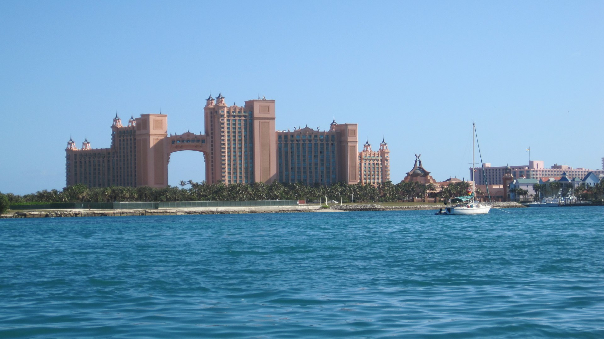
Anchored at 25°04.54′N 077°18.60′W, Nassau
Charged the batteries: ran the engine for two hours. Didn't break out the generator, since we think we're leaving Wednesday.
Started planning the return trip to the US.
-
Exumas to Hen and Chicken Shoal abut end of February, beginning of March. This is a leisurely two weeks to cover only two hundred miles.
-
Thence to Beaufort in a 4-day off-shore trip. (500 nm!) Followed by several days of rest and recovery.
-
Thence to Norfolk through the ICW to arrive near the end of March. We can afford to anchor for a while at Hospital Point and get organized for the next leg.
-
Finally to Annapolis to arrive mid-April and look into getting a dodger built, plus fixing numerous other things that are wearing out or require parts we're not finding in abundance here in the Bahamas.
We wandered over to the fabulous grocery store at the City Market. Bought some staples and some fresh produce. Plus a gallon of distilled water to top up the batteries.
At Starbucks, we ran into the crew of Que Sera Sera and chatted with them about their plans. They're heading further S to pass hurricane season somewhere in the Caribbean (perhaps Trinidad.)
Dinner was macaroni and cheese plus broccoli. Good news: we're finally finished with the case of Kona Longboard ("Island Lager"). Not hoppy enough for my delicate taste buds.
Travel
| Attribute | Value |
|---|---|
| Arrive | Anchored at 25°04.54′N 077°18.60′W |
19th. Tuesday
Anchored at 25°04.54′N 077°18.60′W, Nassau

Weather looks acceptable to start our trek to the southern Exumas tomorrow. It will be a more moderate wind from the E (mostly) hopefully staying between ENE and ESE. It will (eventually) clock to S, which will stall our progress until it moves to W.
We loaded our 40 gallon bladder and two jerry jugs into the dinghy and drove about a mile down the bay to the Texaco Star Port station on the west side of Potter's Cay.
Motoring directly into a one- to two-foot chop in a little inflatable is a ride that delivers a head-to-toe soaking. Waves break over the bow of the dinghy. Add three hundred pounds of water keeping the dinghy close to the waves is an important part of this morning's involuntary sea-water shower.
Dinner was tofu fried rice.
Travel
| Attribute | Value |
|---|---|
| Arrive | Anchored at 25°04.54′N 077°18.60′W |
20th. Wednesday
Starting at 25°04.54′N 077°18.60′W, Nassau
We had been encouraged to use two anchors in the Nassau East Bay. This means the boat spins in a much smaller arc. It also means the anchors can twist around each other.
In really bad situations, one anchor might even trip the other anchor, leaving the boat adrift with a useless mess hanging below. To avoid this horrifying situation, we used one chain rode and one rope rode. It seems like the rope rode might tend to stay top of the chain; if so, this would avoid a tangle that might trip an anchor.
This morning, we pulled up the secondary anchor by hand. No windlass. The rope, short chain and Bruce anchor held us solidly during the big storm that came through. It came up reluctantly. We had never used it before. We're very pleased with it's tenacity. Breaking it out of the sand was some very heavy lifting. It's important to squat and stand to pull in line; bending over a nearly immovable object like a well-set anchor is a recipe for a pulled back at best. You could be pulled off balance and get injured banging into the bow pulpit; or worse still, knocked right off the boat.
The trick is to let the normal up-and-down of the bow pry up the anchor. When the bow dips, squat, pull in some line and stand up. When the bow raises, simply hold the line and let the buoyancy of the boat do the work.
Once that anchor was cleared out of the way, we could haul up the primary Rocna normally (using the windlass). Even with all that work, we were under way shortly after 0800, bound for Allen's Cay.
We navigated the dangerous coral heads of the Yellow Bank successfully. We'd never seen an isolated coral patch before: we didn't really know what to look for.
Then we saw one. Ahem. They're obviously different from the surrounding water. No problem, mon.
CA stood on the rail and pointed them out.
What's important, too, is the advice not to transit the area after dark. For us newbies, the 1100 to 1400 time offered ideal visibility. We could see the coral heads quite clearly. In the dark… the mind recoils in fear of how that could turn out very badly.
We listened to other boats (i.e., Asante, Rainbow's End and Adagio I) discussing the merits of Allen's Cay and Highborne Cay. Based on their conversations, we switched our destination to Highborne Cay. Roomy. Comfortable. Pretty. We don't get to see the Iguanas, however.
Dinner was a bean and potato concoction that might have been good rolled in a tortilla shell. But it was too wet, so we ate it like a thick soup or thin stew. The issue is that pressure-cooker versions of recipes use much less water than open pot versions. How much less? Sometimes, that requires several experiments. This is worthy of a repeat to get the water right.
Anchored at 24°42.703′N 076°49.746′W, Highborne Cay
The night is clear, the winds are light.
Wow.
Travel
| Attribute | Value |
|---|---|
| Depart | Nassau 25°04.54′N 077°18.60′W |
| Arrive | Anchored at Highborne Cay 24°42.703′N 076°49.746′W |
| Time | 8h 10m |
| Motor | 5h |
| Distance | 31.0 nm |
21st. Thursday
Started at 24°42.703′N 076°49.746′W, Highborne Cay
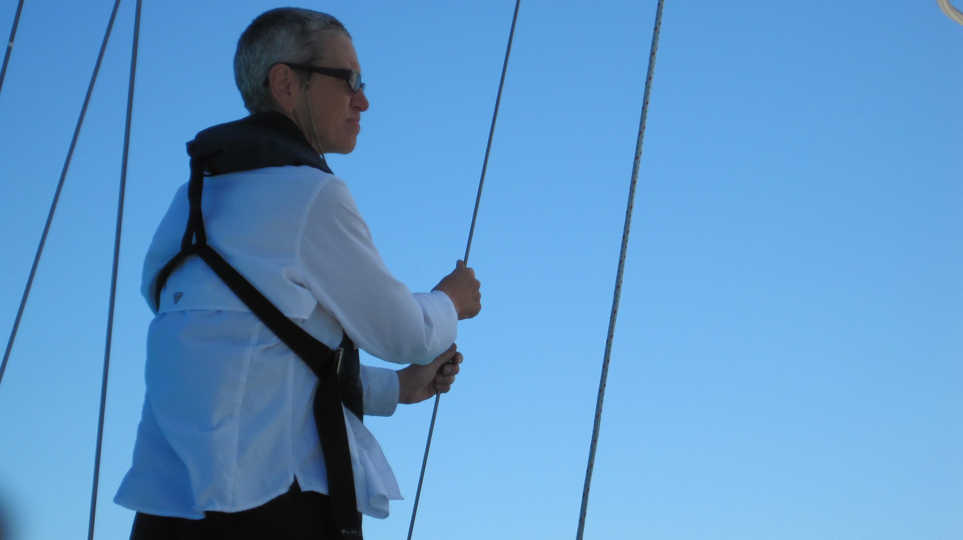
This morning, the wind was delightfully sporty. So sporty, we started out sailing with just stays'l, reefed main and mizzen. We banged along at a good clip.
Sadly, with wind coming from about 110°, we couldn't really do much better than sailing due S at about 180°. That was good for the first hour or so. From Norman's Cay on, however, we were unable to follow the rhumb line course.
Instead of sailing directly for Warderick Cay, we sailed farther (and farther) off the wind. It was great sailing, but the price to be paid was motoring dead to windward for the last few hours.
CA decided to take a mooring in the Exuma Cays Land and Sea Park. She thinks that it's a good thing to pay for a mooring that's part of a park. This way, we can support the efforts to maintain the island environment.
The correct protocol is to call on channel 9 at 0900 to reserve a mooring ball for the next day. If if they're not full up, maybe get a ball the same day. We didn't do any of that. Instead, we simply called up late in the afternoon. The park (specifically Jen) gave us a ball in the "Emerald Rock" mooring field without the formality of a reservation. Delightful.
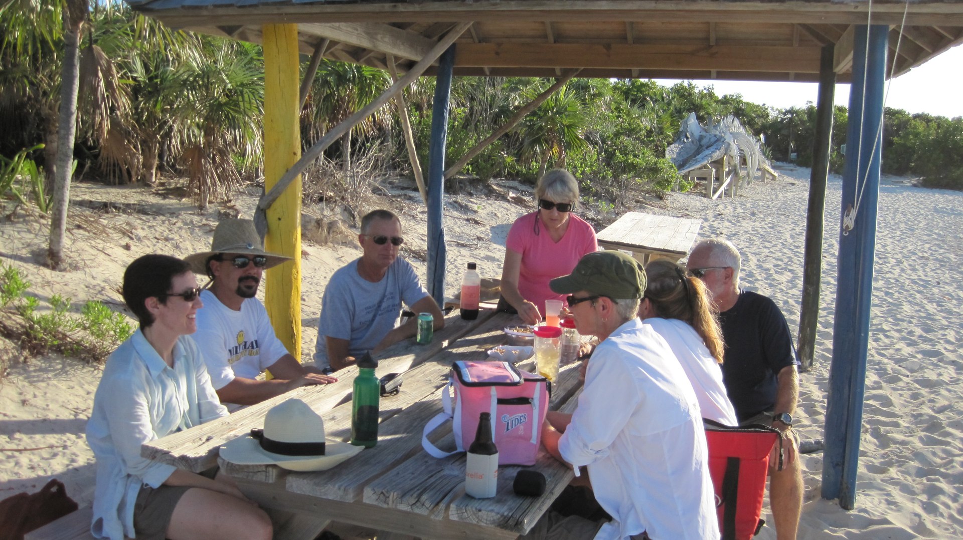
It turns out that the cruisers often have little get-togethers on the beach that has the whale skeleton. There's a regular Saturday night gam. But some cruisers simply get on the radio and announce a beach rendezvous. 1630 to 1830. Bring your own.
Even More Delightful.
The crew of Moonraker hails from Annapolis. If things go well, we might be able to use their community marina dock space to have our dodger installed. Their marina guest fees would be much less than a transient slip at a commercial marina. They're spelunkers; they insisted that we visit the blow holes and be sure to wear sturdy shoes while hiking around. Good advice. Really good.
Moored at 24°22.959′N 076°37.454′W, Warderick Wells Cay
Dinner was quinoa with broccoli.
CA discussed the "How long can we stay?" and "When must we turn around?" questions. The short answer is "Nassau by March 11." That means we have about three more weeks before we have to be in Nassau, ready to run across TOTO to Chub Cay.
We have numerous boat repairs and upgrades on our list. We need to be in Annapolis in April to get them underway. Play-time for this year is limited. In the future, we may be driven more by hurricane season insurance rules: North of Cumberland Island, Georgia, by June 1.
Travel
| Attribute | Value |
|---|---|
| Depart | Started at 24°42.703′N 076°49.746′W |
| Arrive | Moored at 24°22.959′N 076°37.454′W |
| Time | 7h 20m |
| Distance | 33.5 nm |
22nd. Friday
Moored at 24°22.959′N 076°37.454′W, Warderick Wells Cay
Hiked around the Exuma Cays Land and Sea Park today. Wow. What a delightful place.
The 0900 mooring list process showed exactly how busy the park is. We were lucky to get a mooring without being on the list.
We hiked down to Rendezvous Point. This is 1-2 hours of steady walking down there and another hour or so going back. Beyond Emerald Beach, the trail markings get pretty thin. Making progress requires a fair amount of exploring and backtracking. Patience and plenty of water are important.
Someone needs to donate a few thousand plastic disk trail markers, nails and a nail gun to the park. Currently, they use small paint blazes on trees and rocks, but the paint has faded and peeled on the less popular trails.
After lunch, we hiked up Boo Boo Hill. And over to the Blow Holes. The trail markers here are unmistakable.
After that, we were simply exhausted.

Word to the wise. Wear sturdy shoes: the footing on these coral-reef islands is treacherous. The beaches are sandy, but everything that sticks up out of the water is a kind of porous limestone, chewed into fantastical shapes by the action of sea, wind and rain.
Water is helpful, too. It is hot and dry.

There are a number of hiking destinations across the island. There's Pumpkin Flats, Palmetto Flats, Pirate's Lair Boa's Hangout, Rendezvous Point. They're not all equally exciting, but it does mean you can spend plenty of time walking the island. A day or two is not enough.

Boo Boo Hill has become an immense shrine. Cruisers offer pieces of decorated driftwood. We're all adrift on the stormy sea of life, aren't we?
Mooring fees are a mere $20 per day. Wi-Fi is a painful $15 for 24 hours or 100 megabytes.
CA did a small load of laundry in the bucket.
Dinner was some more Alu Mattar.
Travel
| Attribute | Value |
|---|---|
| Arrive | Moored at 24°22.959′N 076°37.454′W |
23rd. Saturday
Moored at 24°22.959′N 076°37.454′W, Warderick Wells Cay
There is a huge amount of activity looking for moorings tomorrow at the marine park. We're so happy that we're here already, not waiting for a mooring at a nearby anchorage. While it's very rolly in the Emerald Rock field, a mooring is better than being anchored.

One old plan we once had was to move from here to Black Point, Great Guana Cay; then Lee Stocking Island; finally Georgetown on Great Exuma. This is three more longish legs of sailing, two of them in the Exuma Sound. Ideally, we would wait for winds from the N, and it could take a week or two to get three good sailing days in with appropriate winds.
A newer plan we've discussed was to take a long (25nm) motor-sail S to Blank Point on Great Guana Cay when the wind is light tomorrow. Then sail N to Staniel Cay,picks up on Tuesday. In effect, we'll be starting our return voyage without ever having gotten all the way to the fabled Georgetown.
Warderick Wells is lovely in an isolated, wilderness kind of way. But we're not all-wilderness-all-the-time kind of people. We don't mind getting "away from it all" for a brief period. A week or so. But we also like a coffee shop and a neighborhood bar. We're firmly torn between the delightful isolation of sailing and the crowding of urban anchorages and mooring fields.
Also, $15 for Wi-Fi rankles. We've heard that there's a cyber-cafe on Staniel Cay that will satisfy our urges.
CA washed the cabin sole and changed the water filter; important domestic chores.
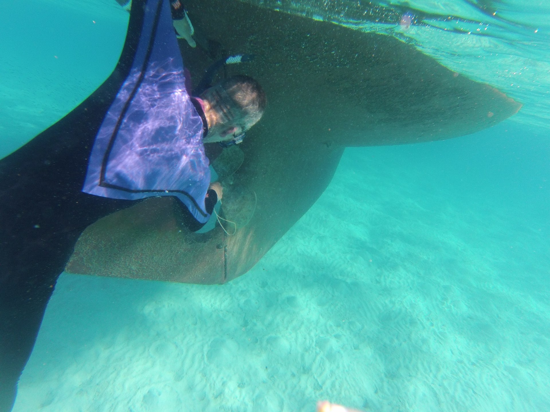
After lunch, we finally went snorkeling on two of the coral heads near Emerald Rock. Not great, but still pretty healthy looking little patches of reef. A great place to test out the GoPro Hero3 camera for underwater use.
After sight-seeing on the reef, she wanted to clean the barnacles off the propellor. That was goin well until a shark showed up. It was a very small shark. But it's was hanging out in the shadow under Red Ranger. A rather alarming thing to see when you're just innocently scraping barnacles.
And.
It's Saturday Night at Warderick Wells. That means cruiser meetup on the beach from 4:30 until whenever. As soon as we had washed up and put the snorkel stuff aside, we grabbed some beers and a jar of nuts to share and took the dinghy to the "Whale Skeleton Beach" to meet some other cruisers who have stopped here.
Delightful.
Dinner was macaroni, broccoli and a cheese sauce concocted from dried soups.
Travel
| Attribute | Value |
|---|---|
| Arrive | Moored at 24°22.959′N 076°37.454′W |
24th. Sunday
Started at 24°22.959′N 076°37.454′W, Warderick Wells Cay
Today started with a short, sweet trip to Staniel Cay. All of 18.4 nm, motoring to windward the entire way. Sort of tedious, but it was only about 4 hours of engine time, and we're in another delightful spot. Perhaps more delightful because there's water, fuel, laundry and perhaps a restaurant in our future.
Unlike Warderick Wells Cay, we have BaTelCo coverage, so we can do a little bit of email.
Since there was almost no wind, the seas are flat. So I dove the prop to check the zinc anode, grounding plate, hull paint and our dozen or so through-hull fittings.
-
Zinc Anode: Half gone. This requires tools to replace, so we'll see if we can rent a tank of air and use SCUBA gear to do this properly.
-
Grounding Plate: Barnacle Colony. More scraping needed.
-
Through Hulls on Starboard Side: Oyster and Barnacle Rest Farms. Yes. We had an oyster living on one of our through-hull fittings. Others were so jammed with barnacles, that we could see why our deck drains were so slow.

I got worn out scraping the growth off our fittings on the starboard side. So I didn't check the port side at all. Maybe tomorrow.
Bonus #1, there was a small shark up near the anchor. Very photogenic. Since I was making a video using the GoPro Hero3, I caught it on video.
Bonus #2, thee are feral pigs on Big Majors Spot. Save your kitchen waste, throw it on the beach.
Dinner was a minestrone with orzo and potatoes.
Anchored at 24°13.650′N 076°20.400′W, Big Major's Spot, near Staniel Cay
Travel
| Attribute | Value |
|---|---|
| Depart | Started at 24°22.959′N 076°37.454′W |
| Arrive | Anchored at 24°13.650′N 076°20.400′W |
| Time | 4h |
| Distance | 18.4 nm |
This Week
Engine Hours: 18. Diesel Gallons: 0. Water Gallons: 0. Miles Run: 80.
Books: The Honourable Schoolboy, Smiley's People, Goodbye Junie Moon, High Crimes: The Fate of Everest in an Age of Greed, Winnemucca, a small-town fairy tale.
Read Aloud: A Feast for Crows: A Song of Ice and Fire.
Travel
| Attribute | Value |
|---|---|
| Engine | 18. h |
| Fuel | 0. gal |
| Water | 0. gal |
| Distance | 80. nm |
