

Big trip South. Followed by big trip East. After almost two months of not moving an inch, we've moved hundreds of miles south, followed by a hundred or so miles east into the Bahamas. Parts of the trip were a piece of cake: the weather along the Florida coast was benign. Parts of the trip were a bit of a struggle: crossing the Great Bahamas Bank isn't easy.
We had settled into the comforting arms of St. Augustine. Yoga. Running. Coffee shop. Friends. Daily Cruiser's Net on the radio. Every two week get-togethers with other cruisers.
How do you leave that for the unknown of the Bahamas?
4th. Monday.
Started about 29°03.032′N 080°39.076′W, motor-sailing off Cape Canaveral

Shortly after midnight, Mr. Benmar (our trusty helmsman) stopped working.
For the next nine hours, in lumpy seas, we hand-steered. This is a brutal undertaking.
A little steering on a breezy afternoon, or during a race, is fun. Eight hours of steering is horrible. You can't pee, you can't scratch, you can't stretch. You can't take your eyes off the path of moonlight across the water because the waves will spin the boat around, and leave you pointing entirely the wrong way.
Worse, there's no end to the ordeal. When the autopilot is out, the only alternative to hand-steering until you either fix it or decide to pull on somewhere and replace it.
I spend a fair amount of time fantasizing about replacement autopilots.
At 0300, we needed to gybe the sails. That means that CA has to scramble around the deck while I steer. That means no one is sleeping. She has to grind in the yankee, release the mizzen preventer, center the mizzen, switch the running backstays prior to the gybe. Then I turn the boat. Then she has to pull out the yankee, ease the mizzen and reset the mizzen preventer. Knowing she'll have to get up at 0600 to take over the helm.
Happily, Mr. Benmar came back on duty at about 0900.

Why? How? What went wrong? What changed? No clue. I have some theories, but no evidence.
For the next twenty-eight hours, Mr. Benmar operated flawlessly: all the way to Ft. Lauderdale.
Some time in the morning I passed a huge flock of sea-birds. Quite hard to get a good picture of them, since they looked like tiny black dots hovering over the waters. If I was fishing, I would have loved to wet some line there.
Dinner was another steaming bowl of Hopping Johnny.
Ended at 27°11.168′N 080°08.375′W, motor-sailing off St. Lucie Inlet
Travel
| Attribute | Value |
|---|---|
| Waypoint | Motor-Sailing about 29°03.032′N 080°39.076′W |
| Waypoint | Motor-Sailing about 27°11.168′N 080°08.375′W |
| Time | 39 h |
| Distance | ? |
5th. Tuesday
Started at 27°11.168′N 080°08.375′W, motor-sailing off St. Lucie Inlet
Winds light, seas flat. Mr. Lehman chugging along happily. Mr. Benmar steering. We can easily do 4-on, 4-off watches. CA made various kinds of snacks to eat during the day. She finds that 4-on, 4-off works well for her. She can get a solid four hours of sleep and feel good coming on watch.
I was worried that four hours on watch might be too fatiguing. The 1800-2200 (right after dinner) watch turned out to be pleasant; CA just stays up until 10-ish while I nap. The 2200 to 0200 isn't too tiring, because I just got four hours of sleep. The 0200 to 0600 (after four hours of sleep) includes dawn, which is very energizing. CA loves it.

We spent the night and the morning hugging the coast. We were told by old salts to stay within the 5-fathom depth contour south of 27° (the Jupiter Inlet.) That means staying within ½ mile of shore. A scary prospect at night. Essentially, you sail toward shore until you get to 15' of water, then you sail offshore until you get to 30' of water.
By about 1300, we'd arrived in the Port Everglades, Ft. Lauderdale inlet.
While we were bound for Key Biscayne, we wouldn't arrive there until almost sundown; so The Commodore decided that we would stop at Ft. Lauderdale in full daylight before pressing on.
We needed more time to explore Lauderdale. It looked like fun. Real fun.
But the Friday weather window was calling.
Two other boats, Chardonnay and Grace, were also in Lauderdale. Plus, the folks next to us in Lake Sylvia remembered us from St. Augustine. Sadly, we didn't remember them. We've got to pay closer attention to our neighbors.
Mr. Lehman had just reached 200 hours since the last oil change, so I did the needful. We carry 8 quarts of 30-weight, plus a spare filter, plus two empty gallon jugs. The oil change is mostly a matter of dealing with the mess of oil drips everywhere. I did manage to spill (and mop up) a lot of oil. Ugh.
ICW-wise, we're approximately at mile marker 1064. St. Augustine is about 777. We covered about 287 statute miles of the ICW. Our offshore distance was about 257 nautical miles (295 statute miles) slightly further. But no bridges. And easier to do at night.
Dinner was macaroni with a sauce based on a random instant soup and a zucchini.
Tomorrow we'll get started as soon as possible to top off the fuel and sail down to Key Biscayne. It's just 30 nautical miles away, so we shouldn't have too much difficulty in getting there during daylight.
The weather for the Gulf Stream crossing (we've finally subscribed to Marine Weather Center) includes the phrase "another fantastic E-bound opportunity, which continues thru Sunset Fri8." We're inclined to set out super early Friday morning and attempt the crossing.
We've been advised that it's sometimes best to fly the "Q" flag, pass by the eastern-most islands (Cat Cay, Gun Cay, Bimini) and cross the Bahamas Bank to Chubb Cay. It's more expeditious to check in at Chubb Cay and plan the trip to Nassau from there. The anchorage is more protected and you can monitor the conditions in the Tongue of the Ocean—a 6600-foot deep undersea canyon—between Chubb Cay and Nassau.
Anchored at 26°06.303′N 080°06.677′W, Lake Sylvia in Ft. Lauderdale
Travel
| Attribute | Value |
|---|---|
| Waypoint | Motor-Sailing about 29°03.032′N 080°39.076′W |
| Waypoint | Anchored Lake Sylvia 26°06.303′N 080°06.677′W |
| Time | 53 h |
| Distance | 257 nm |
6th. Wednesday
Started from 26°06.303′N 080°06.677′W, Lake Sylvia

This was a pleasant day sail. It shaped up like this:
-
Wake up early.
-
Fix a serious wiring problem with the starter.
-
Get out of Lake Sylvia without running aground.
-
Get fuel, oil, oil cleanup pads.
-
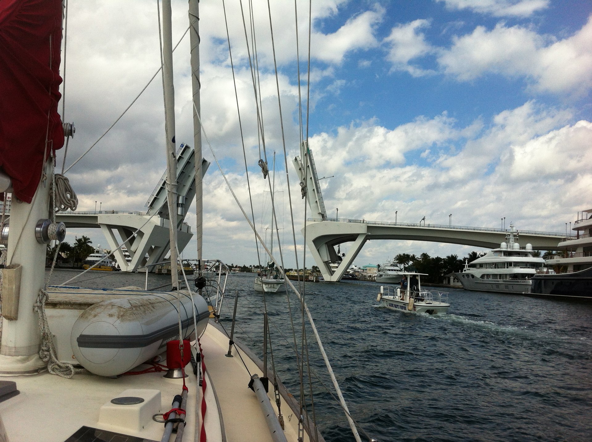
Miss the 0800 bridge opening by 3 minutes.
By 0830 we were out under the 17th street bridge and into the Atlantic. At about 1500 we were anchored in Key Biscayne. Ahhh. Day sailing. No overnight passage.
One of the Go Pro Hero3 brackets broke (in a small way.) The M5 (metric) "acorn nut" that holds it together dropped off. Into the ocean. Drat. Sadly, it's the most important bracket, the one that clamps to the various poles and stanchions around the boat.
Sailed and motor-sailed to 25°40.595′N 080°09.801′W, No Name Harbor, Key Biscayne
No Name Harbor is a hair bigger than Lake Sylvia, but still very small. We wedged ourselves in after a little jockeying for an position that didn't crowd other boats. About sunset, Grace showed up. So we invited Mark over for a dinner of faro and a sauce made of random dried soup and zucchini.
If the predicted weather holds, we're leaving Friday.
Travel
| Attribute | Value |
|---|---|
| Depart | Lake Sylvia 26°06.303′N 080°06.677′W |
| Arrive | No Name Harbor 25°40.595′N 080°09.801′W |
| Time | 7 h |
| Distance | 26 nm |
7th. Thursday
Anchored at 25°40.595′N 080°09.801′W, No Name Harbor, Key Biscayne

Up early to help CA take a run around the park.
Had a little visit with a Chinese family sight-seeing in the park. Many of them knew a few words of English, and one of them was an English teacher, so we managed to nod and smile and point at the boat and wave and pose in each other's pictures.
We found the laundry. One washer. One dryer. But it works and waiting around on a south Florida beach looking out over the ocean isn't such a bad way to wait for a free machine.
Bonus: there's fashion photography going on. Models. Clothes. An amazingly posh classic wooden sailboat.
CA took a walk into town to visit a hardware store and an ATM. M5 nuts for the Go Pro. Plus cash for the Bahamas. Our silly American habit of throwing around credit cards won't work.
Dinner was the grilled snapper at the waterfront restaurant in the park itself.
The impending Gulf Stream crossing involves a fair amount of stress: ➤Open Ocean, ➤International Travel, ➤Possibly Hellish Weather; lots of ➤Scary Unknowns.
But wait.
The Bahamas are only 42 nm away. We've recently done a 250 nm passage. We can motor there in just 8 hours, worst case, using only 8 gallons from our 75 gallon tank. If we leave the Fowey Rocks Light at about 0600, we're onto the Great Bahama Bank at 1400.
Travel
| Attribute | Value |
|---|---|
| Arrive | Anchored at 25°40.595′N 080°09.801′W |
8th. Friday
Started from 25°40.595′N 080°09.801′W, No Name Harbor, Key Biscayne
At 0400, Asanté (A Brewer 18, also in No Name Harbor) and Red Ranger raised anchor for the crossing to the Bahamas. This was the first time we'd tried to handle close maneuvering around anchored boats and narrow channels in the dark.

Once out into the Straits of Florida, with the Bahamas more-or-less ahead, we put up all of our sails, and continued to run the engine. While sailing is better than motoring, we needed to get through the Gulf Stream expeditiously. Dawdling around trying to be sailing purists might have lead to arriving after dark.
We went through the gap between Gun Cay and North Cat Cay. Our mark was 25°34.40′N 079°18.30′W. While this is about 099°M we steered about 120°M to counter the Gulf Stream current. According the the authors of the Explorer Chartbook, the Gulf Stream current should moderate as we closed with the Bahamas.
We didn't see any moderation in the current. We were steering 20° S right up until we went through the gap.
The Great Bahamas Bank was nothing like the Straits of Florida. Nothing. It was another world.

The ocean was blue and had 2-3' waves. The Bahamas Bank was green and flat. Absolutely flat.
The wind moderated, and we felt much warmer.
We drifted along under all full spread of canvas, amazed by the flat, green water. It was delightful.
BaTelCo's automated system sent as a text inviting us to sign up for an extended data plan for our iPhones. We're should probably $30 per month for 120Mb of data so that we can receive our Caribbean Weather email every day.
Our understanding of the weather was this: tomorrow (Saturday) would have wind from the N, perfect for the Great Bahamas Bank crossing. It a trip of 58 nm, 10 hours of brisk sailing, which means it usually takes two days. The plan (according to lots of folks) is just drop the hook anywhere. 30 miles from whatever. It's okay. It will be fine with no obvious shelter; the barrier islands are 30 miles away, but they're working.
Dinner was pasta and "veggie-burger balls" in a vodka tomato sauce.
Anchored at 25°32.519′N 079°03.277′W, Great Bahamas Bank
Travel
| Attribute | Value |
|---|---|
| Depart | No Name Harbor 25°40.595′N 080°09.801′W |
| Waypoint | Gun Cay and North Cat Cay 25°34.40′N 079°18.30′W |
| Arrive | Anchored at 25°32.519′N 079°03.277′W |
9th. Saturday
Started at 25°32.519′N 079°03.277′W, Great Bahamas Bank
The wind came up and switched during the night. Not unexpected. What was unexpected was the degree of shift. Instead of getting a useful N wind, we get winds from ENE gusting to 20 knots. Since this is within 45° of the direction we want to go, this is going to be an ugly slog.

Motorsailing under stays'l, we beat to weather for the entire day. With some care, we could pinch up to 30° off the wind and get decent boat speed. The yankee might give more speed, but won't allow such a high course. The main would help, but seas were lumpy and no one wanted to go out on deck to raise it.
Seas and winds then proceeded to build slowly during the day.
Dinner was rice and lentils. Simple comfort food.
The deck-mast joint has started to creak. It's a loud, scary creak. The mast is solid: all the shrouds and stays feel tensioned properly; there's no visible motion at all; the blocks holding the mast base into the keel are all rock solid. We're not sure what—exactly—is creaking, but we're going to have to take the mast boot cover and possibly the interior woodwork apart to see what's started moving.
Anchored at 25°28.283′N 078°24.499′W, Great Bahamas Bank
Travel
| Attribute | Value |
|---|---|
| Depart | Started at 25°32.519′N 079°03.277′W |
| Arrive | Anchored at 25°28.283′N 078°24.499′W |
| Time | 7h 21m |
10th. Sunday
Started at 25°28.283′N 078°24.499′W, Great Bahamas Bank
Day two of slogging directly to weather. Today the seas were higher, and the wind stronger than yesterday. We saw gusts of 30 knots.

After bashing around for four hours, it was clear that we'd never make Chub Cay today. We dropped the anchor after noon. We're just shy of the North West Channel. We'll wait here—at the edge of nowhere—for the wind to clock E and SE. We heard some radio traffic from Silver Spray that hinted that the wind would also moderate. If this forecast is true, we may make Chub Cay tomorrow, a day later than we'd hoped.
It's important to note that we can't see anything but water. No land. No lights. Nothing.
Weird.
CA baked chocolate muffins.
Dinner was a pasta with "field greens and snaps".
Anchored at 25°30.293′N 078°13.974′W, Great Bahamas Bank
Travel
| Attribute | Value |
|---|---|
| Depart | Started at 25°28.283′N 078°24.499′W |
| Arrive | Anchored at 25°30.293′N 078°13.974′W |
| Time | 2h 20m |
| Distance | ? |
This Week
Engine Hours: 68. Diesel Gallons: 103. ICW Miles: 318. Miles Run:93.4.
Books: "The Dark Night" screenplay.
Read Aloud: A Feast for Crows: A Song of Ice and Fire.
Travel
| Attribute | Value |
|---|---|
| Engine | 68. h |
| Fuel | 103. gal |
| ICW Distance | 318. mi |
| Distance | 93.4. nm |
