

It's feeling like time to move on. St. Mary's is nice. Very, very nice.
The weather has been fabulous. Biking to the grocery store looks pretty easy. The anchorage feels secure.
But.
Cumberland Island is nearby. So is Fernandina Beach. The First Coast stretches South of us. Then the rest of Florida. Facebook status shows us friends in St. Augustine, Titusville and points yet further south.
The Commodore hears the Bahamas calling to her, faintly in the distance.
3rd. Monday.
Started at 30°43.030′N 081°33.149′W, the St. Mary's River.

Starting around 10:30: (1) stow Scout (the dinghy), (2) move to the town dock, (3) take on water, (4) eat lunch, (5) move to Cumberland Sound, right by the ranger station and ferry dock, (6) anchor.
Ended at 30°45.982′N 081°28.310′W, the sound behind Cumberland Island.
Anchor watch from 14:30 to 17:00. This included taking a shower, reading, knitting and checking Facebook (through the painfully slow AT&T Edge network; why can't AT&T upgrade their infrastructure?)
When the tide goes down here, it really goes down. Mud banks started to appear to our left and right at ¾ tide. At low tide, the lost continent of R'lyeh seems to have appeared off our port bow, only to be swallowed again by the rising tide in a few short hours.
We read about Florida's abusive laws on boat registration, taxation and anchoring. We found that it is not prudent to use the phrase "live-aboard" in Florida. There are adverse legal consequences to being a live-aboard. In the state of Florida, we are instructed to use the word "cruisers". Really.
That was our busy day.
Florida, because of some weird frenzy of "state's rights", apparently refuses to honor the US Coast Guard documentation of a vessel. Virginia, on the other hand, treats the US Coast Guard documentation with the same degree of respect that most sovereign nations treat it. Not Florida. Almost everywhere else in the world, the US Coast Guard documentation is sufficient. Not Florida. We have to register Red Ranger in a way that'a acceptable to Florida somehow or risk their wrath.
Dinner was Tuna and Grits. (We wanted to make Shrimp and Grits, but Lang's Restaurant in St. Mary's only sells 5 lb. packages of shrimp. A bit much for two of us with no freezer.)
Time: 4 hrs. Distance: 5.1 nm rhumb.
In St. Augustine, consistent with Florida's general level of rudeness to boaters, there's very limited free anchoring, but lots of expensive moorings. We need to book one in advance. That means studying the chart to see where we need to go so that we can get groceries and mail once we get there.
Travel
| Attribute | Value |
|---|---|
| Depart | Started at 30°43.030′N 081°33.149′W |
| Arrive | Ended at 30°45.982′N 081°28.310′W |
| Time | 4 h |
| Distance | 5.1 nm |
4th. Tuesday
Anchored at 30°45.982′N 081°28.310′W, the sound behind Cumberland Island.
Paid our park fee ($4 ea.) and hiked around the South end of Cumberland Island National Seashore. We didn't get how the names work until we started hiking around.
Dungeness? Stafford? Plum Orchard? What are the? Villages? Geographic features like points or bays?
No.

The names are the estates. Vast vacation compounds for the unbelievably wealthy.
Ah.
Dungeness, in particular, may be a allegory on unfettered free-market capitalism.
It was overbuilt, unsustainable, and brittle. A change in the economy around 1916, and the estate became worthless.
Before the robber barons, the island also hosted plantations. The plantation system generally depended on enslaved labor. After emancipation, those vast estates became unsustainable.
Could the money have been spent more wisely? There's no way to know.
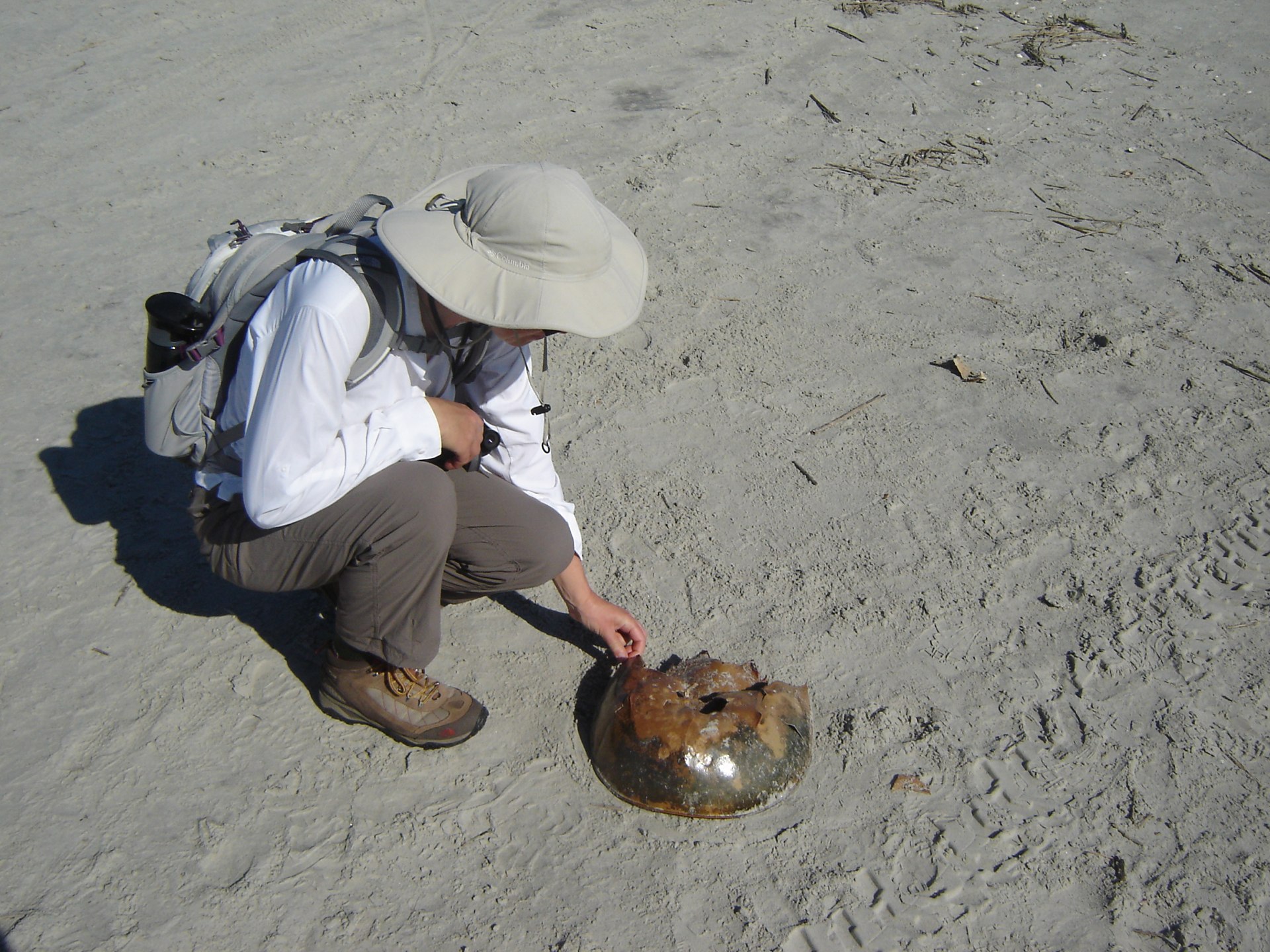
The beach is an amazing thing to see. I don't think I've ever seen wild beach before. No lifeguards. No snack bars. No umbrella rentals. Just birds, shells and the remains of horseshoe crabs.
Talked with Mike of Sturdy Logic, from Ithaca, New York.
Dinner was fried rice with random veggies.
Travel
| Attribute | Value |
|---|---|
| Arrive | Anchored at 30°45.982′N 081°28.310′W |
5th. Wednesday
Anchored at 30°45.982′N 081°28.310′W, the sound behind Cumberland Island.

Took a hike up to the Stafford camping area along the "Parallel Trail". The National Park Service map said "showers" vs. the "cold-water showers" down here at Sea Camp. They were also cold-only showers. But it was a great hike.

The most important part was finding armadillos. We also saw turkey and one wild horse. But we'd never seen armadillos on the hoof before.
Since our garden isn't involved, all the digging is just cute. I guess if you have them living near your house, they're a large pain in the neck.
Talked with Kay and Melissa of Morningstar. They're heading south toward St. Augustine after spending a few days at the seashore.
Dinner was a thick soup including potato, cabbage and coconut milk.
Weather tomorrow (in zone AMZ452) still seems to be suitable for a short overnight broad reach to the south, starting in the late afternoon Thursday, including Thursday night and a little bit of Friday morning.
Thursday And Thursday Night: Northeast winds 10 to 15 knots. Seas 3 to 5 feet. Inland waters a moderate chop. Scattered showers.
Friday: East winds 10 knots. Seas 3 to 5 feet. Inland waters a light chop. Scattered showers.
The "Seas 3 to 5 feet" is a little troubling. That can be a bit "sporty", perhaps more sporty than we like. But it's one night and there are lots of "duck-in" opportunities along the coast, including Jacksonville as well as running right back into St. Mary's.
Travel
| Attribute | Value |
|---|---|
| Arrive | Anchored at 30°45.982′N 081°28.310′W |
6th. Thursday
Started at 30°45.982′N 081°28.310′W, the sound behind Cumberland Island.
About 15:00 we pulled up the anchor, flowed down the Cumberland River with the ebb tide just like we knew what we were doing.
That was about the last really good thing we did all day and parts of the next day. The next 16 hours will turn out to be pretty messy.
The ebbing tide went roaring out into the Atlantic Ocean against the prevailing wind, leading to very, very lumpy seas in the inlet.
How Lumpy?
Green water over the bows.
For the non-sailors, there's two types of water over the bow.
-
White water is spray and and the kind of foam and slop that looks cool in a picture. It spatters on the dodger and makes everything sort of salty on deck.
-
Green water is the the boat plunging into ocean, with water rolling down the decks, filling the bulwarks and draining out the scuppers. It sprays off the chainplates. It will knock anchors loose and launch anything unsecured on deck overboard. Because of Red Ranger's center cockpit design, we're safe and dry from green water. Other boat designs (low, fast racing boats, for example) lead green water through the cockpit to drain aft: a cold, wet prospect.
When Red Ranger launches herself off the top of a wave that's over (guessing her) six feet high, the bow sprit itself will then fall at least 12 feet into the ocean with a large "slap" followed by the next wave breaking over the bow.
While this is scenic, and not particularly harmful to Red Ranger, it's unpleasant for the crew.
Mistakes Were Made
Once into the channel, we realized that (a) our anchor marker ball was flying around forward, (b) the level for operating the windlass was sliding around the deck and (c) the anchor washdown hose was still out there. Of these, the hose is the least destructive and can safely be ignored. The ball has a counterweight which will smash something, plus it has a long prop-tangling line on it. The lever is heavy, destructive and absolutely critical to handling the anchors.
When we were finally out of the St. Mary's channel and started heading S (with the seas instead of across them), CA could put on her harness and tether and creep forward to secure the loose items. It took some time to gather up the courage required to work forward a second time on the heaving deck.
Ordinarily, we keep an hourly journal of our progress while sailing. We also try to take a few pictures.
Today was an exception. The conditions were so "sporty" (wet, pounding and unnerving), that we couldn't put the camera, log book or even a pen in the cockpit. They'd get soaked or wind up underfoot (or both.) We could not find a good location for our water bottles or the cracker box. We didn't even break out the puke bucket; we were forced to hurl straight over the side (or into the scuppers) as best we could. It was that kind of night.
Scott (of Joie de Vivre) gave us a great deal of comfort when we told us that night really is worse than day for seasickness. Why is night worse? No visible horizon.
Big Seas
We've been in seas of four feet. It was pretty sporty, but we managed without too much trouble.
Years ago, I was on Just Us in seas that were apparently 10'. We stood in the cockpit and looked up at passing waves. Those waves were widely-spaced and none of them were breaking. Under a single reef in the main, the motion felt pretty good. I'm still unclear on why this wasn't bad.
The prediction for our overnight passage was three to five feet. Assume the worst: five feet. Is that 25% sportier than four feet? Or, is motion not tied directly to wave height? In our case, there were two distinct trains of waves: one short-spaced train from the NNE that was on our quarter and created an uncomfortable roll; a second train from the ENE that was more widely-spaced and much, much larger. We'd fall down into the valley between those big waves with an annoying, knock-you-off-your-cockpit-bench roll.
Our judgement was impaired. The biggest mistake I made was keeping our speed up to 5 knots. Leaving St. Mary's channel at 17:00, we need to go slowly to make it a 12-hour trip to arrive at 07:00 the next morning. Sadly, we didn't keep our speed down. Habitually, we kept it up at 5 knots, dooming us to an early arrival and subsequent beating back and forth in big seas.
CA was too sick to make a hot meal, and too sick to even attempt going below. She stood watch for almost five straight hours while I slept below in the warm, dry bed.
Tossed Around
The motion of Red Ranger was so disorienting that I could barely get dressed to go on deck. I almost lost my previous meal just climbing the companionway ladder. I thought it was some passing nausea. While I was sitting in the cockpit, trying to catch my breath, looking for the horizon, getting a face full of fresh air, I passed out cold.
I fell off the cockpit bench on down to the floor of the cockpit and lay there.
At first, CA couldn't figure out what happened. One moment I was sitting there, the next moment, there's a pile of clothes and gear on the floor of the cockpit. She grabbed me and started shaking me, and eventually I came to. At first, you're dreaming of someone shouting. Then you're dreaming of CA shouting "Steve!" Then you're half-asleep and she's shouting at you to wake up. Then you're awake, wondering what the fuss is all about. Then you realize what must have happened. That must have been very scary for her.
I didn't feel very bad after my involuntary nap, and was able to stand watch for several hours while she slept on the cockpit bench.
The stars were beautiful. Thunder showers off our port bow created a fabulous electrical display. The moon rose into a night that was sparklingly clear.
The wind died away to almost nothing, forcing me to furl the sail instead of having it flog uselessly.
Dinner was granola bars.
Motor-sailed to approximately 30°05′N 081°16′W, somewhere between Jacksonville and St. Augustine.
Time: 7 hours. Distance: 40 nm rhumb.
Travel
| Attribute | Value |
|---|---|
| Depart | Started at 30°45.982′N 081°28.310′W |
| Waypoint | Motor-sailed to approximately 30°05.0′N 081°16.0′W |
| Time | 7h |
| Distance | 40 nm |
7th. Friday
Start at approximately 30°05′N 081°16′W
Sometime after midnight, my head was clear enough, and the motion easy enough that I could read the chartplotter in short bursts of concentrated effort. Followed by long periods of looking away to try and find the horizon.
I realized that, it our present speed over ground (SOG) we'd make the St. Augustine inlet at around 03:30. Smart sailors don't enter unknown anchorages in the dark. They wait for day. I furled the last of the sails and throttled back the engine to idle so we wouldn't be too early. I also steered further off-shore in an effort to waste time.
Toward dawn, the stars vanished into clouds.
At around 04:00, we could finally turn toward St. Augustine, hoping to arrive sometime after 06:00 in the early pre-dawn light.
The light never really arrived. The sun didn't come up; it just got a hair brighter.
As we got closer and closer to the inlet we realized that we were sailing in a fog, and the pre-dawn grey was all we were going to get.
Aids to Navigation
We were ecstatic when we found the flashing white light (with a loud horn) that announced the entrance to St. Augustine.
After that came the hard part.
-
The seas had built to over six feet (according to NOAA weather), so we had breaking waves crashing into the inlet. We were going to surf our boat—our home—through breaking seas.
-
The cut with shoals so eternally shifty that the charts show nothing except "see note". "The entrance channel is subject to frequent changes of in depth and direction because of shifting shoals. Buoys are not charted because of frequent changes in position. Mariner's are advised to seek local knowledge." They best you can do is to subscribe to the weekly Local Notices to Mariners (LNM) to track the position of the aids to navigation. The Active Captain web site provides some advice on the LNM information on the shifting channel, also. None of which helps much at 06:30 when you're too sick to look at the chart plotter for long.
CA spotted the marks by hanging out of the cockpit far enough to have a clear view. She told me where to steer to thread Red Ranger though the fairway into St. Augustine. Only one of the marks was lit.
Once inside, (at about 07:45), we dropped the anchor temporarily to wait for the 08:30 bridge opening. After we passed through the bridge, we picked up mooring M-27.
Even snagging the mooring was challenging. Twice, I failed to put the engine in neutral and drove away with CA struggling to hold the mooring pendant. The third time was the charm; I finally noticed my mistake and dropped the engine in to neutral after she had hooked the mooring.
Moored at 29°53.03′N 081°33.15′W, St. Augustine.
Once secure, I collapsed and took a two hour nap. CA cleaned up the decks, rinsing off the puke. She cleaned and showed the things below that had come adrift in the high seas. She's made of sterner stuff than I am.
Scott of Joie de Vivre stopped by to welcome us to St. Augustine.
Dinner at Harry's.
Time: 9 hours. Distance: 11 nm rhumb, 64 miles ICW. Total of 55 nm offshore from St. Mary's.
Travel
| Attribute | Value |
|---|---|
| Depart | Started at 30°05.0′N 081°16.0′W |
| Arrive | Moored at 29°53.03′N 081°33.15′W |
| Time | 9h |
| Distance | 11 nm |
8th. Saturday
Moored at 29°53.03′N 081°33.15′W, St. Augustine
We started the day with the 08:00 cruiser's net. On Marine VHF channel 72, they check in and discuss the day's events, equipment for sale or exchange, questions about the locale. Very, helpful and welcoming.
We went to the Hidden Harbor Marina yard sale. It seems like a nice place: "small, liveaboard friendly". For now, we'll stay on a mooring ball in the river.

Then, for even more fun, we went to the famous Sailor's Exchange. Every boat part you could ever possibly want is here. It's just a matter of finding it.
Our other exciting trip today is laundry. The marina has four washers (and four dryers) making laundry quick and reasonably pleasant.
Maybe next Saturday, we'll look for the Old City Farmer's Market on Anastasia Island.
We're going to try and take in the holiday parade of boats tonight at around 18:00. The issue is the fog. It's been foggy since we got here, and a parade of lighted boats—in the fog—would not seem to reflect a Christmas spirit. It would be more like mystery lights at sea.

This year's Christmas Miracle: the fog lifted from about 17:45 to about 19:45, allowing the parade to pass in all it's glory. After dinner, the fog was so thick we had trouble finding Red Ranger in the mooring field.
Dinner at the House of Barley irish pub.
We've got some chores to look into while we're here. The Sailor's Exchange and West Marine are only a few miles away by bike or bus, so we should make some minimal effort to finish a few of the tasks that we've been leaving for later.
For example, I've got a box of parts for installing two more small solar panels; so I suppose I should actually do that. Also, I can order a replacement propane hose now that I have a delivery address. I hope to finish the dinghy registration (if Walker Bay has finally sent my Manufacturer's Statement of Origin to our mail forwarding service.) And—to comply with Florida's ridiculous policy on registration—I need to get a "registration without title" from the Commonwealth of Virginia.
Travel
| Attribute | Value |
|---|---|
| Arrive | Moored at 29°53.03′N 081°33.15′W |
9th. Sunday
Moored at 29°53.03′N 081°33.15′W, St. Augustine
Today's cruiser's net (08:00, channel 72) provided an introduction to some of the other boaters here in the St. Augustine area. Plus useful information on the Sunday Farmer's market, bus stops, and nautical trivia.
CA and Scott took off for the local Yoga studio at around 10:30.
I was left until about 13:00 to look closely at our journey south. The MapTech Florida chartbook breaks Florida's Atlantic coast down into three slightly overlapping sections: North (border to Cape Canaveral), Central (Cape Canaveral to Ft. Lauderdale) and South (Jupiter Inlet to Key West). We're well into the North; I'm just trying to get into the Central section; let's not over-plan this.
There are some hard-to-answer questions for the next two or three likely stopping places.
Titusville
One question for us is "Titusville: Yay or Nay?"
-
Yay. It's a popular stop on the ICW.
-
Nay. It's on the ICW; the nearest inlets are Ponce de Leon inlet (mile 840) near New Smyrna Beach) and the Ft. Pierce Inlet (mile 965). That's 125 miles of the ditch, 25 hours of motoring. We would have to find anchorages and avoid shoals for three days just to get back outside again.
If we avoid Titusville, we have to sail outside around Cape Canaveral: this is only about 110 nautical miles, a 22 hour trip outside; less than the Charleston to St. Mary's trip. As long as we can find a weather window with a moderate sea state, this would be fun.
Day or Night
The other hard question is how to tackle the St. Augustine to the Ponce de Leon inlet trip. This is only 53.6 nautical miles. If we dawdle along at 4 knots, we can drag it out to 13 hours, suitable for an overnight passage. If we sail more aggressively and can actually sustain an average of 6 knots, we can do it in 9 hours, making it a possible day sail.
The problem with a day sail of 9 hours is that we can't be late. An extra hour of sailing means that either we're anchoring in the dark or we spend the night beating back and forth (or drifting) waiting for dawn. We would need to drop the mooring and anchor N of the Bridge of Lions; if we leave in the same kind of grey pre-dawn that we arrived in, we can stretch the day by an hour or so.
Charts and Support
I broke down and purchased additional electronic charts for the Bahamas from Wavey Line Charts. While NOAA gives away the US charts, foreign charts aren't cheap. X-Traverse allows downloads to two devices: computer and iPad seem like the logical choices. While the iPhone does work well, the small screen isn't ideal for most practical navigation problems. The downloads are (of course) huge, so we need to spend some quality time sitting in the lounge watching bits dribble through the ether. This gives us paper, chartplotter, computer and iPad charts.
An annoying subtlety is that the free NOAA RNC charts—when grouped by Coast Guard district—seem to omit the ICW small-scale detail charts. There are, it appears, hundreds of these detail charts; they're packaged into the state-level downloads not the district downloads. In this case, the Florida state download (which duplicates much of the district 7 download) seems to include the ICW details.
The ICW detail charts, also, appear rotated; the GPSNavX software doesn't display them in their correct orientation.
But. There's a better alternative: Fugawi X-Traverse provides better packaging than NOAA. Their NOAA District 7 download seems to include the details. Very nice.
The afternoon errands amount to two things: getting gasoline for the dinghy and making some bike repairs. Back in August of 2011 we bought a full three gallon tank of gasoline for the dinghy. After almost 18 months, we're starting to reach a point where we might run out of that venerable gasoline.
Dinner was a strip of salmon, cheesy potatoes, kale and raw peas.
Puffin came in to the mooring field right after dinner. They're heading out early in the morning. It could have been another opportunity to spend time in the local watering holes, if they were hanging around.
Travel
| Attribute | Value |
|---|---|
| Arrive | Moored at 29°53.03′N 081°33.15′W |
This Week
Engine Hours: 16. Diesel Gallons: 0. ICW Miles: 64.
Books: finished The Night Manager and An Ordinary Person's Guide to Empire.
Read Aloud: A Storm of Swords: A Song of Ice and Fire (still; it will be a while).
Travel
| Attribute | Value |
|---|---|
| Engine | 16. h |
| Fuel | 0. gal |
| Distance | 64. mi |
