

Summer Land Cruising is almost over. Hurricane season is an unholy mess — looking at people struggling with Ida, but, also heading toward a conclusion. We still have to get back to Deale, where Red Ranger is docked.
Which means the start of Red Ranger's south-bound cruise.
And that means a shakedown around the Chesapeake.
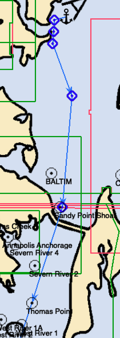
CA's first destination: Hart-Miller Island State Park. The snapshot is half the course at a small scale of 1:490,800 where the island doesn't even show up. But I put an anchor there to mark the destination. And the start of the return leg.
I find planning to be one of the best parts of cruising: the arm-chair sailing in anticipation of the various kinds of problems we might have and bail-outs we might need. Or "day-dreaming" if we're really going to be honest about it.
We say "different ships, different long splices." We all have distinct approaches to planning.
Here's mine, for what little it might be worth.
Visualization/Day Dreaming
I like to start with AquaMap and OpenCPN. I really like to see the baseline charts. I also like the simple, obvious data sharing in OpenCPN: files. AquaMap has a clever web integration for data sharing; this is OK when you have the world-wide-intrawebs, but less than optimal when you're not connected.
The community details in AquaMap are handy for locating anchorages, obstructions, and what-not. The simple data sharing from OpenCPN means that I prefer to create routes in OpenCPN based on reading AquaMap.
Export the Base Route
Once we have the primary waypoints in a route, we can export this to an easier-to-fiddle-with form.
I have custom software to transform a GPX file to a CSV file that can be loaded into a spreadsheet. I can also take the tabular display from OpenCPN and make a useful CSV out of that. (Plus a bunch more things.)
Add ETE and ETA computations
OpenCPN and AquaMap can do estimated time enroute (ETE). OpenCPN adds in estimated time of arrival (ETA). But. It's a pain to fiddle with.
If I was not a programmer, I suspect I'd be perfectly happy changing dates in OpenCPN to figure out latest departure, earliest arrival, and the like. But. Since I am totally a computer programmer, I have fancy software in Python and spreadsheets to help me understand arrival times, departure times, daylight hours, and the like.
The equirectangular distance computations in Ed Williams' Aviation Formulary are a great way to get useful distances along a rhumb line that are good enough for sailing. In effect, you're converting the change in latitude to a distance N and the change in longitude to a distance E. The hypotenuse of this little triangle is close enough to the haversine formula for distance that we can all be happy.
Given distance and speed, ETE is easy. Here's the tricky part: figuring forward from a departure time or figuring backwards from an arrival time. It's a small change to the way the cells compute a rolling total. Neither approach is "best" because each leg of a voyage has it's own unique considerations.
Intermediate Waypoints
We figure we shouldn't push the hours-underway envelope unless there's a compelling reason. We've arrived at a general feeling that six hours of travel is a big day out. We don't have a great reason for this. It means sailing from 10AM to 4PM. You know, pleasant, daylight hours with plenty of pre-departure prep and post-arrival anchor watch.
Bottom Line
I've got the following — it's a bit of a jumble when formatted for the blog — but this the data from my spreadsheet.
| Leg | Order | Lat Deg | Lat Min | Lon Deg | Lon Min | distance (NM) | bearing (°T) | Speed | ETE | ETA |
|---|---|---|---|---|---|---|---|---|---|---|
| HHN Entrance | 12 | 38 | 45.9 | 76 | 33 | 0.5 | 154.8 | 5.0 | 0h 7m | 2021-09-15 8:00 |
| Herring Bay G3 | 11 | 38 | 45.4 | 76 | 32.7 | 1.2 | 168.9 | 5.0 | 0h 15m | 2021-09-15 8:06 |
| Herring Bay | 10 | 38 | 44.2 | 76 | 32.4 | 1.5 | 65.8 | 5.0 | 0h 17m | 2021-09-15 8:21 |
| Herring Bay G1 | 9 | 38 | 44.8 | 76 | 30.7 | 5.8 | 26.5 | 5.0 | 1h 9m | 2021-09-15 8:38 |
| Chesapeake 85A | 8 | 38 | 50 | 76 | 27.4 | 3.8 | 19.2 | 5.0 | 0h 46m | 2021-09-15 9:48 |
| Thomas Point | 7 | 38 | 53.6 | 76 | 25.8 | 7.6 | 17.8 | 5.0 | 1h 32m | 2021-09-15 10:33 |
| Sandy Point Shoal | 6 | 39 | 0.9 | 76 | 22.8 | 8.5 | 4.7 | 5.0 | 1h 42m | 2021-09-15 12:05 |
| Brewerton Channel | 5 | 39 | 9.4 | 76 | 21.9 | 4.2 | 20.3 | 5.0 | 0h 51m | 2021-09-15 13:46 |
| Pleasure Is Ch S | 4 | 39 | 13.4 | 76 | 23.8 | 0.9 | 4.9 | 5.0 | 0h 11m | 2021-09-15 14:37 |
| Pleasure Is Ch N | 3 | 39 | 14.3 | 76 | 23.7 | 0.9 | 4.9 | 5.0 | 0h 11m | 2021-09-15 14:48 |
| Hawk Cove G3 | 2 | 39 | 15.2 | 76 | 23.6 | 1.0 | 77.9 | 5.0 | 0h 11m | 2021-09-15 14:59 |
| Hart-Milller Is | 1 | 39 | 15.4 | 76 | 22.4 | 7h 11m | 2021-09-15 15:10 |
This is the start of my turn-by-turn plan for working our way up the bay.
We have to fold in another consideration. We'll need fuel. I think we're below half a tank. While this trip should use 10 of the 36 gallons we have, we're about to leave the comfy confines of a dock.
So, we'll probably break this into two days up with a stop for fuel somewhere. We've never been up the Magothy river, so Atlantic Marina looks appealing. The other choice is Pleasure Cove on Main Creek off Bodkin Creek off the Patapsco. We've never been there, either.
We have bunches of other things to get ready, but, this trip gives us a goal. We can weigh the jobs against "will this make us ready enough to go to Hart-Miller?" Once that's done, we're looking at the real trip to Charleston, SC.